Hoodline is following the proposed police redistricting plans in central San Francisco. Coverage of the SFPD's Tenderloin community meeting and SFPD’s Northern Station community meeting offer recaps of the neighborhoods’ feedback on the original boundary proposal. Now, here’s the latest from the Police Commission's April 8th meeting, which examined four potential boundary maps developed based on the public’s feedback.
The San Francisco Police Commission plans to vote next week on a final police district map. The commissioners and Police Chief Greg Suhr reviewed four new boundary map options, which reflected changes the commission requested based on feedback gathered from members of the affected districts, during the commission's regularly scheduled meeting on April 8.
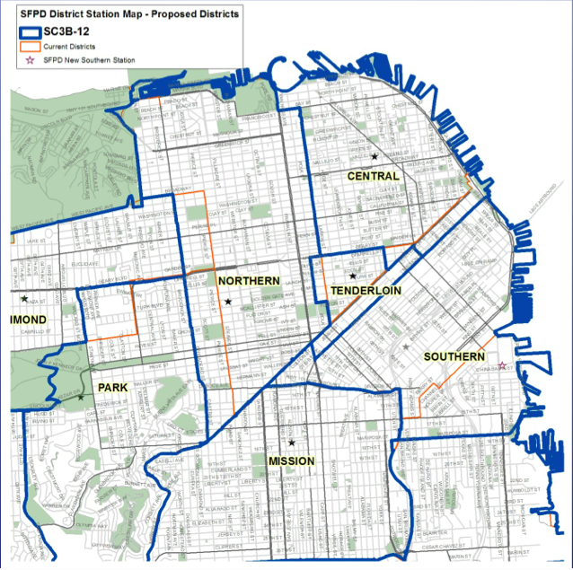
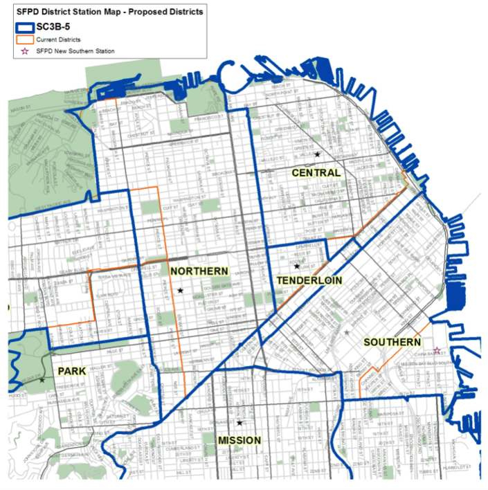
The commission narrowed the selections down to one map (below) for voting next week — after the Tenderloin district’s western border is further refined based on the commission’s understanding of the community's requests.
Kym Craven, director of Public Safety Strategies Group — the consultancy facilitating the redistricting process — walked the commission through a variety of district maps that illustrated specific changes requested by the communities in the Tenderloin, Park, Richmond, Southern, Bayview and Mission police districts.
She also shared analysis of data that showed how the changes would affect computer-aided dispatch calls (CAD), incidents that are investigated as a result of CAD calls (CABLE) and population size in each district. Read on for highlights from the commission’s discussions regarding changes to boundaries of the Tenderloin, Park and Richmond districts.
Tenderloin District
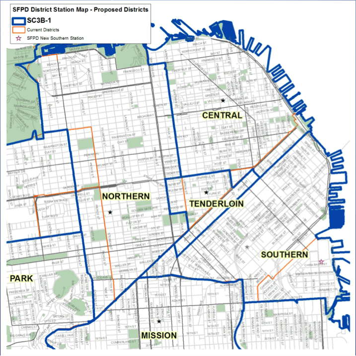
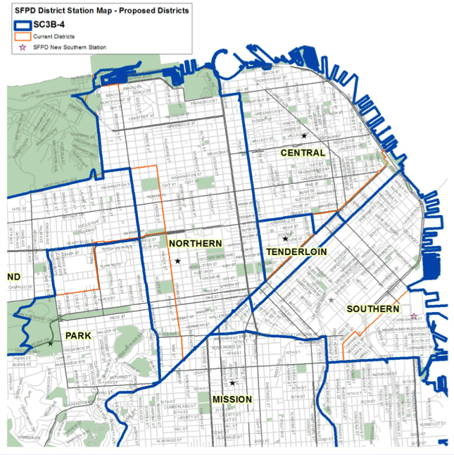
The commission focused much of the redistricting discussion on the Tenderloin district, and reviewed two alternative options that would move the western border from Larkin Street to Polk Street or Van Ness Avenue, while keeping City Hall and Civic Center Plaza in the Northern District. The commission’s major concern was how to appease the community’s request for a western border expansion without overwhelming the district’s resources.
According to Public Safety Strategies Group’s analysis, placing the western border at Van Ness or Polk would have a very small impact on operational resources and population size. The Van Ness border would increase CAD by 1.2 percent, CABLE by 1.1 percent and the population by .5 percent, while a Polk Street border would result in a .7 percent CAD increase, .6 percent increase in CABLE and .3 percent increase in population.
Option 1: Western Border to Van Ness Avenue
Option 2: Western Border to Polk Street
However, Craven said that the commission should consider that either alternative border would result in no clean lines for the Tenderloin district, and excluding City Hall and Civic Center Plaza would compromise interconnectivity between the Tenderloin and Northern districts.
Based on conversations with Tenderloin Station Police Captain Jason Cherniss, Northern Station Police Captain McEachern and Central Station Police Captain David Lazar, as well as community members, Chief Suhr said that the district’s main request is to become fully staffed and have access to as many officers as possible. To accomplish that goal would mean keeping the eastern border at Market Street ending at Third Street (so the Market Street beat officers would join the Tenderloin district), and ending the north-south streets at Mission—with the Southern district keeping Mission Street.
Chief Suhr also stated that, despite the data, Captain Cherniss and Captain McEachern believe that the better western border for the Tenderloin is Larkin Street, due to Polk Street’s need for beat officers, and an “inordinate” amount of calls and demonstrations.
Commission President Suzy Loftus promptly reminded the board of the “tremendous feedback” received from the Tenderloin community on the western border. “We heard loud and clear from the community that Larkin Street was not their request,” she said.
The discussion then turned back to how to handle City Hall, with Commissioner Victor Hwang noting that CAD and CABLE statistics do not take severity of issues into consideration. A large demonstration at City Hall would be counted as one incident, he said.
“If you want the most staffing and you’re thinking about consideration of your facilities, consideration of what happens outside of City Hall, it’s really difficult to get all of the Tenderloin together the way you envision it,” Craven responded. “When we look at where the events happen, you’re pushing it outside what the street configurations are, so there’s this spill over into other districts. So you either need to capture the City Hall piece of it together or it all needs to come together. And quite frankly I’m not sure that the city is prepared to enact the types of overarching changes that it would need to take.”
Furthering that sentiment, Chief Suhr warned the commission that if the Tenderloin’s western border expanded to Polk or Van Ness, the Federal Building would become part of the Tenderloin district. Noting his 34 years of experience on the force, he said, “Sometimes the President is not a Democrat, and the Federal Building is a bigger issue than other times. And we redistrict every 10 years.”
Other discussion topics for the Tenderloin district included staffing for a western border at Polk or Van Ness (no new officers would be added to the Tenderloin District, Chief Suhr said) and an eastern border at Market Street (the station that receives Market Street gets the 36 beat reporters assigned to the street). The commission clarified that its general order — not the final map —will dictate which station handles each border street, but the goal is to have one station handle both sides of major boulevards.
President Loftus also announced, and Chief Suhr confirmed, that the request to remove the Westfield Mall from the Tenderloin district had been withdrawn and including the shopping center in the district was “livable for the Tenderloin”. This was echoed by a public commenter who said, “I’m kind of settled with it now. You gotta give something to get something.”
Four additional members of the public addressed the commission, with two urging the commission to extend the western border to Polk Street and two simply thanking the commissioners for their hard work and consideration of the neighborhood's needs.
Park & Richmond Districts
Craven presented two alternative maps to the commission, both with the ultimate goal of keeping the NoPa neighborhood together in one district.
The first option involved moving Park district’s northern border to Geary Boulevard. This is projected to increase CAD calls by .8 percent, CABLE by .8 percent and population by 1.4 percent. The second option called for moving the Richmond district’s border south to Fell Street, resulting in a .7 percent increase in CAD, .6 percent increase in CABLE and .8 percent increase in population. As Public Safety Strategies Group found that the impact to either neighborhood would be relatively the same, Craven and Chief Suhr recommended moving Park’s border to Geary to keep all of the businesses on Geary in one police district—Richmond.
Option 1: Park Northern Border to Geary Boulevard
Option 2: Richmond Southern Border to Fell Street
President Loftus said moving Park’s northern border to Geary reaches the commission’s goal of “preserving neighborhoods where possible, and it does achieve that interest,” and the discussion promptly ended with all of the commissioners in agreement.
There was no public comment on this meeting.
Public Safety Strategies Group is currently working with the Controller's Office and Police Commission to solidify the additional requested changes to the Tenderloin district’s western border in the final map before the commission votes in its next meeting, which is scheduled for 5:30pm on April 15th, at City Hall Room 400. We’ll let you know the outcome shortly after.


