Prepare for a bout of stormy weather, Austin residents. The National Weather Service anticipates a 50 percent chance of showers and thunderstorms today, marked by mostly cloudy conditions and highs peaking near 82 degrees. Strong south winds of 15 to 20 mph, with gusts hitting as high as 30 mph, are also on the docket. Rainfall should range from a tenth to a quarter of an inch but could increase amid thunderstorms. The evening brings increasing cloudiness and lows around 71, maintaining brisk winds from the southsoutheast that may reach up to 25 mph in gusts, according to the National Weather Service.
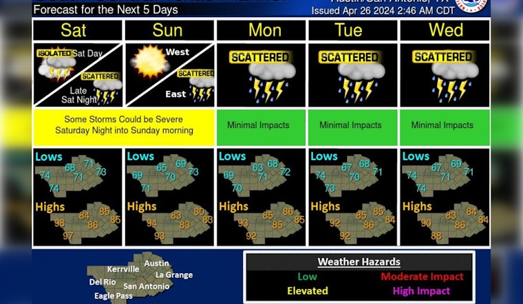
Today will be mostly cloudy and warm with isolated to scattered storms possible. If any storms do develop some storms could be strong. Otherwise, highs will be in the 80s to middle 90s with the warmer values near the Rio Grande.
— NWS Austin/San Antonio (@NWSSanAntonio) April 26, 2024
Rain chances remain in the forecast next week. pic.twitter.com/xzf6qkfC8A
Saturday's outlook suggests a lesser chance of precipitation with a 20 percent opportunity for showers and thunderstorms post-1 pm. Despite the continued cloud coverage, temperatures are expected to warm up to about 84 degrees, as per the National Weather Service. The wind, originating from the southsoutheast, will intensify throughout the day, potentially generating gusts of up to 40 mph. Moving into Saturday night, the chance of rain and storms increases to 40 percent after 1 am, along with sustained breezy conditions.
These weather patterns are fueled by the convergence of the West Texas dryline and an upper-level storm system, which is forecasted to roll in rounds of storms and showers from Friday through the weekend. While the potential for severe storms throughout today is low, there's a possibility of hail and gusty winds should some storms intensify. "Warm temperatures (80s) and humid conditions," are anticipated regardless of storm activity, with "breezy winds out of the south" reaching speeds of 15-25 mph, sometimes gusting up to 30 mph, KXAN states.
The highest hazard for intense weather is predicted for late Saturday night into Sunday morning, with a slightly more pronounced risk in the Hill Country and a subtler forecast along the I-35 corridor. Rainfall from Friday to Sunday could constitute anywhere from 0.25" to 1.5", yet certain models suggest as much as 2" to 5" could douse parts of Central Texas within the next week. On Sunday, showers are likely, potentially giving way to thunderstorms before 1 pm, with subsequent chances for more rain and thunderstorms thereafter.
Monday forecasts a 20 percent chance of afternoon storms, and by Tuesday, the odds remain the same for both daytime and evening, as reported by the National Weather Service. Temperatures will sit comfortably in the mid-80s under partly sunny skies. The pattern holds through to Wednesday and Thursday, where the likelihood of rain and thunderstorms persist, culminating in highs around the low 80s and mostly cloudy nights with lows near 70.


