Minneapolis residents should brace for a wet and stormy week ahead, with severe weather conditions expected to hit the area today and continuing intermittently through Monday, according to the National Weather Service Twin Cities/Chanhassen MN. The forecast for Minneapolis, MN today includes a 30% chance of showers and thunderstorms post 5pm, with an overall sunny day and a high near 68 degrees. A west southwest wind will set in at 5 to 10 mph before becoming southeast in the afternoon, according to the National Weather Service.
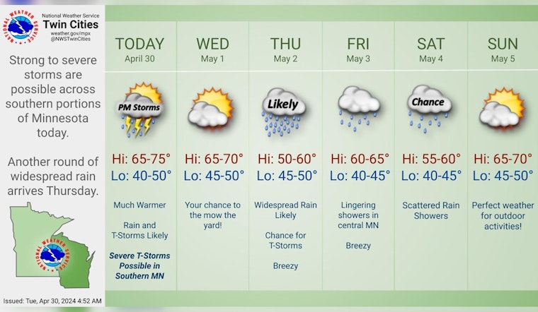
Warmer and stormy! Afternoon highs in the 60s and 70s will be followed up by rain and t-storms this afternoon and evening. Southern MN remains in the Slight Risk for severe weather, where damaging wind gusts, large hail, and an isolated tornado or two are possible. #mnwx #wiwx pic.twitter.com/k8VaqJtLfo
— NWS Twin Cities (@NWSTwinCities) April 30, 2024
Tonight, the chance of precipitation hits a full 100%, with thunderstorms mainly occurring before 1 am. Some of these could release heavy rainfall, and new rainfall amounts could reach between three quarters and one inch. The southeast wind will become west after midnight, potentially gusting as high as 30 mph. Wednesday promises sunny skies, however, with a return to a high near 68 degrees and a west wind blowing at 10 to 15 mph, as per the National Weather Service.
A hazardous weather outlook has been issued for central and southern Minnesota, as well as west central Wisconsin. "A line of thunderstorms is expected to move across central and southern Minnesota late this afternoon and during the evening in western Wisconsin". There's a looming threat of strong to severe storms that could come with 70 mph wind gusts, large hail, and the possibility of isolated tornadoes particularly south from Mankato, as detailed by the NWS Hazardous Weather Outlook.
Looking ahead, Thursday will bring showers and potential thunderstorms with a brisk east wind at 15 to 20 mph, with gusts as high as 30 mph - leading to an 80% chance of precipitation. The inclement weather expected is part of a pattern that will repeat through the week; Friday will see a 30% chance of showers mainly before 8 am followed by partly sunny skies and a calm, with a high near 64 degrees. However, Monday holds a 40% chance of showers and thunderstorms amidst partly sunny conditions with a high creeping up to near 74 degrees, as reported by the National Weather Service.


