Early this year, fresh talk of building a second BART tube to connect northwest San Francisco with the rest of the system garnered attention. But you can find other grand transit visions going back a century or more, many of which could have drastically changed the landscape of the city.
From the 1910s through the 1960s, the thinking mostly involved building highways and freeways for cars, such as the “Divisional Highway” plan of the 1920s that would have gone through the Castro and up Divisadero to the Golden Gate.
But here’s a look at the biggest freeway plan of them all – and how it mostly didn’t happen. Instead, the watershed saga helped make BART a reality, led to a new era of neighborhood activism, and even helped lay the groundwork for the Haight Ashbury culture of the '60s.
The Panhandle Concept
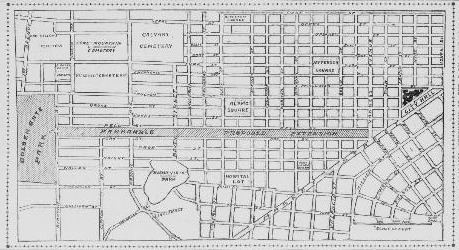
At one point, there was a road through the Panhandle – it was called Avenue Drive. Oak and Fell were two-way streets on the sides.
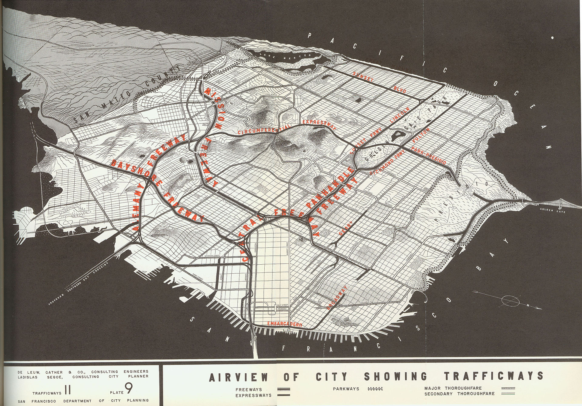
But the bulwarks of state and city governments had for decades been churning with freeway expansion plans, propelled forward by the development of the Interstate Highway System under the Eisenhower administration. The California Department of Highways (now called Caltrans) and city planners envisioned a grand plan bringing the Central Freeway through Hayes Valley, semi-submerging it into the Panhandle, then curving into Golden Gate Park, passing underneath the Main Drive (what is now called John F. Kennedy Drive) and connecting with US-1 at 14th and Fulton. It was to be called the Panhandle Freeway.
The Panhandle, and Golden Gate Park, were designed by civil engineer William Hammond Hall. In reports submitted to the first park commission the Panhandle was referred to as the ‘avenue of approach’ to the larger adjacent park (Chronicle, Editorial, 1955, Nov. 19).
“The thought of the original planners was to extend it downtown,” as one article described it, but in the “late nineties [1890s] voters rejected a bond that would have extended” the park to Market Street. (SF News, July 10 1938, ‘Clipping’).
John McLaren, a park superintendent, engineer, and horticulturalist, used the Panhandle stretch as a testing ground of sorts in the 1800s, in order to see what kind of plants would take root in what was then the ‘Outside Lands’ – the largely sandy western side of the city, that would become the western neighborhoods and Golden Gate Park. By the '50s, it held a great variety of trees and shrubs.
For many now, the idea of a freeway through the middle of city seems a bit odd, to say the least. But the idea arose as part of greater context in the rationalist urbanization movement that was occurring in the US at the time. Particularly influential at the time were the ideas of Robert Moses, whose vision of urban development favored freeways and the automobile over the use of public transit.
The Freeway Expansions
In 1945, the newly formed San Francisco Planning Commission adopted a ‘Master Plan’ which included designs for major thoroughfares along Bayshore, Embarcadero and the Panhandle. The first leg, the replacement of the Bayshore Highway system with a safer freeway, began in 1950 and was completed in 1958.
It made driving up and down the peninsula safer and faster than the previous roads, but it also split up neighborhoods in southeastern San Francisco.When planners proposed an elevated “Western Freeway” along 19th Avenue in 1956, it was rejected by the Board of Supervisors in an 8-3 vote, led by William Blake.
Residents had been watching what happened along Bayshore, recalls Calvin Welch, a long-time activist in San Francisco and a current board member of the Haight-Ashbury Neighborhood Council (HANC). The "no" vote marked the first of many battles to come in that era.
That same year, the San Francisco Chronicle published a map of the long-brewing freeway plans alongside an editorial, that as FoundSF puts it, was meant to chastise the opposition. In the words of the Chronicle:
The remarkable aspect of these protests and claims of injury is their tardiness. They concern projects that have for years been set forth in master plans, surveys and expensive traffic studies. They have been ignored or overlooked by citizens and public official alike—until the time was at hand for concrete pouring and when revision had become either impossible or extremely costly. The evidence indicates that the citizenry never did know or had forgotten what freeways the planners had in mind for them.
The map, though, helped more residents see exactly what they didn’t like about the plan – that it would divide their neighborhoods, remove their park, and in some cases destroy their homes.
Yet the double-deck Embarcadero freeway was opened 1958 and the elevated Central Freeway was opened the next year, bringing a freeway to Hayes Valley.
This particular form of the urbanization of San Francisco appeared to some to be a necessity as the city was losing one of its big economic drivers – the port. The powerful International Longshore and Warehouse Union (ILWU) signed a ‘mechanization and modernization’ agreement with Pacific Maritime Association in 1960, effectively moving shipping activities over to Oakland, where a port designed for multi-modal ‘containerization’ was built.
San Francisco leaders were looking for new business. Bringing freeways into the city was in part a plan to make the city more amenable to commercial real estate.
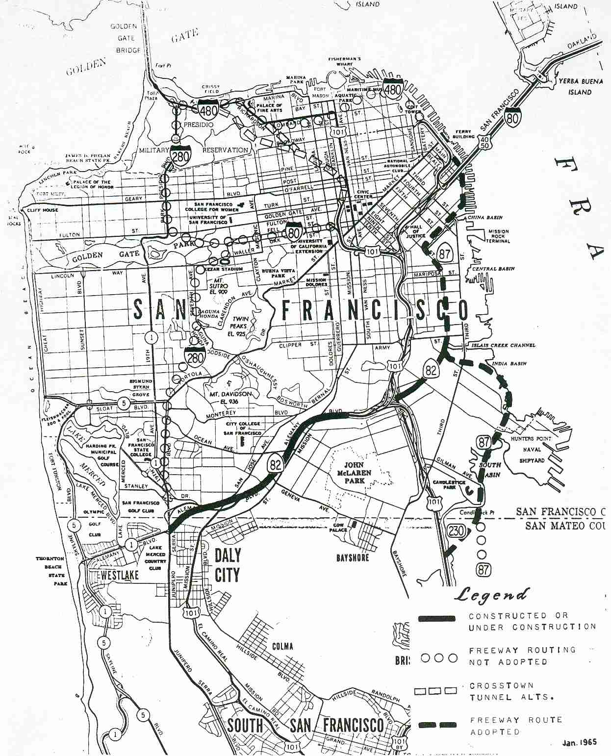
The same year, the Division of Highways and the Planning Commission renewed their calls for freeways running through the city, but instead they proposed depressed freeways or tunneled freeways through the Panhandle and 19th Ave. By 1962, both of these proposals were rejected by the Board of Supervisors, albeit by a smaller 6-5 margin.
Supervisor William Blake instead proposed building a tunnel underneath Pacific Heights, towards the Golden Gate Bridge, thus eliminating the need for freeways on top of the city.
He attempted to get the Pacific Heights tunnel project on the ballot – but at the time many viewed the effort as an empty gesture meant to show labor unions and freeway advocates that he was working hard. It didn’t get enough signatures to make the ballot, but even if it had, the common view was that the well-heeled neighborhoods would make sure it lost the popular vote. The main result of the effort was Blake, a leading politician of the era, earning the nicknames “Tunnel Bill” and “Freeway Bill” for his promotion of the former plans over the latter.
The Panhandle Plan Proceeds
As other efforts stalled, freeway advocates pushed forward with the Panhandle as the main artery to connect northwest San Francisco and the Golden Gate Bridge to the rest of the peninsula.
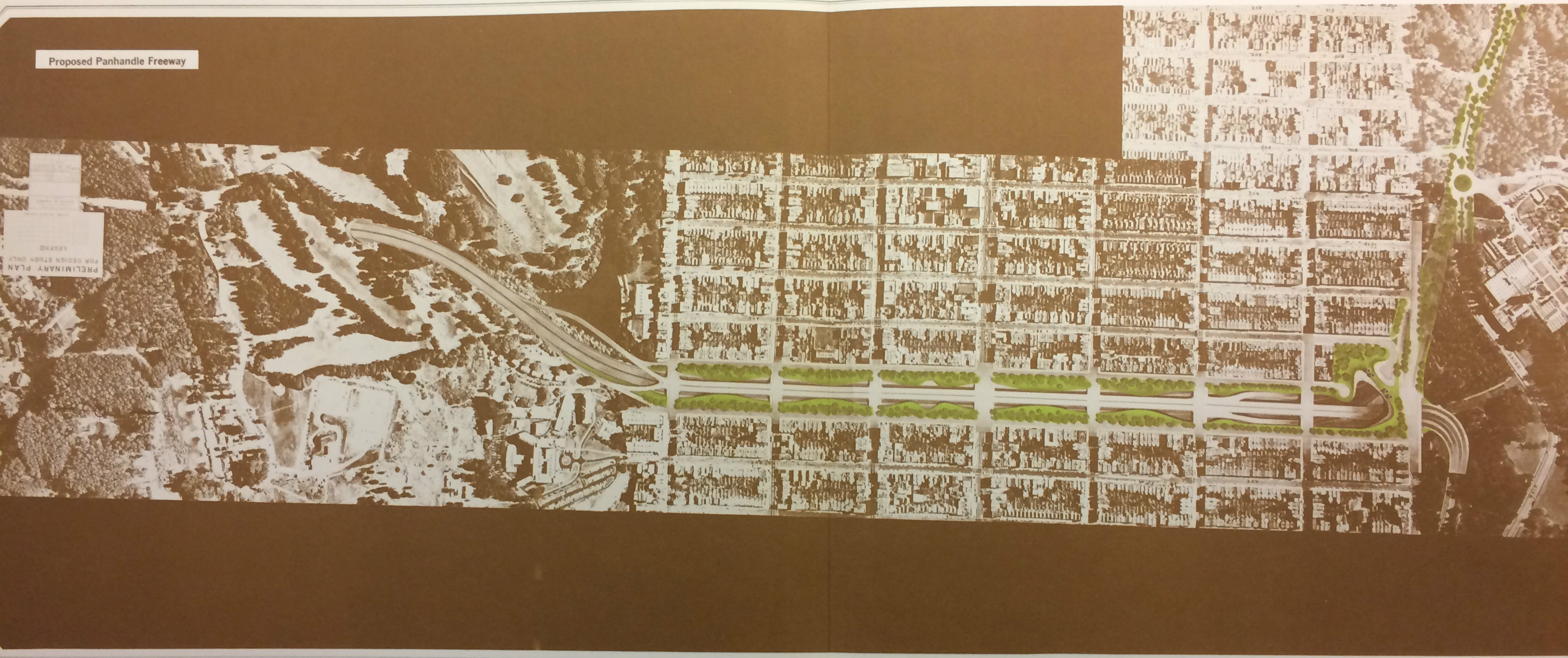
The partially submerged design, showing the connection to the Central Freeway in Hayes Valley. Via the San Francisco Public Library.
After nearly a decade of controversies, the City Recreation and Parks commission unanimously approved the Panhandle proposal on July 10th 1964, despite a large protest Golden Gate Park’s McLaren Lodge (Chronicle, July 11 1964, ‘Panhandle Parkway Approved’). For this reason, many San Francisco old-timers call it the Wreck-Parks Dept.
The continuation of the freeway through Golden Gate Park, the Richmond District, and into the Presidio. Via the San Francisco Public Library.
Following this result, the Division of Highways renewed calls for studies into freeway proposals in March of 1965. One main factor that you can find in newspaper article of the era was that San Francisco had been earmarked $250 million ($1.86 billion in 2015 dollars) in Federal Interstate Highway Funds. This would be lost, Senator J. Eugene McAteer warned, if the city decided not to go forward with the proposals (SF Call, Oct 14. 1964, “MacAteer warns on Panhandle”).
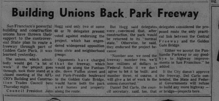
Other influential politicians and interest groups joined in. Governor Pat Brown, the current governor’s father, also urged San Franciscan supervisors to approve the plan (Chronicle, May 1 1964, ‘Brown Will Push for More SF Freeways’). Labor unions, notably AFL-CIO, came out in favor of the proposal as it meant that the workers would get “a lot of work”(Chronicle, May 9 1964, ‘Building Unions Back Parkway Freeway’). Interestingly, according to Welch, the University of California, San Francisco engaged their employees to advocate for the freeway, as it would make the connection between the medical school and UC Berkeley much easier.
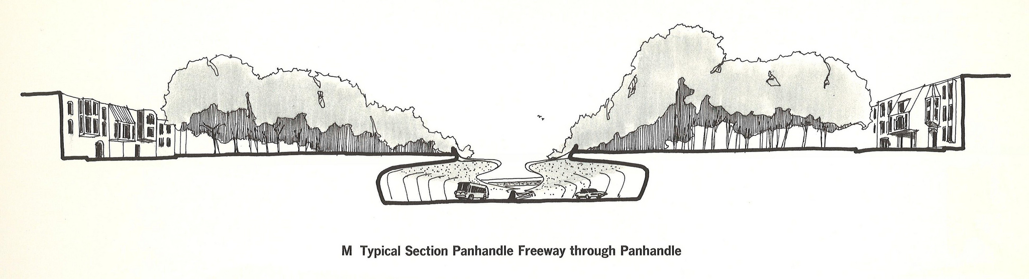
The designers, working with the city planning commission published a report in February 1966 claiming that the freeway project would be in “harmony with the neighborhood pattern and protect the character of the neighborhoods affected” while, “at the same time, removing heavy volumes of traffic from city streets.” In an appendix to this report, as a justification for the project it is claimed: “In an urban design sense, no totally homogenous community is being disrupted. The Panhandle effectively now divides the neighborhoods to its north and south from one another.”
Welch called this particular claim “wacky” because residents from neighborhoods to the north and south would gather there. Other locals, including this author’s parents and family friends, have said the same. The quality of the park had only been going up over the decades. The landscapes planted by McLaren and others in the 1800 were now maturing, at a time when the city still had few street trees.
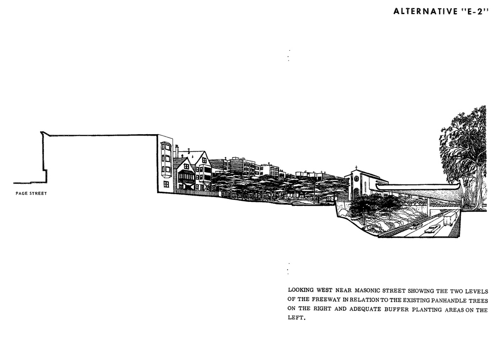
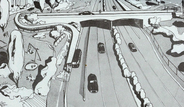
The planners' ideas about preserving Panhandle trees and neighborhood continuity. Via Eric Fischer/WalkingSF.
Beyond the park’s destruction, between 415 and 500 people were to be removed from their homes and relocated away from the Panhandle corridor. "For relocation, it is estimated that the cost the the City will amount to $200,000,” according to a joint city-state study published in February of 1966. “For rent-supplement and air-rights through a redevelopment program, the cost could range from mere credits to a maximum of $3.8 million."
From the reports of the Planning Commission, the authors seem confident that the neighborhood would not suffer from the freeway, and that after two years of construction the park would return to similar use, as it was before the construction were to happen.
Opposition Grows
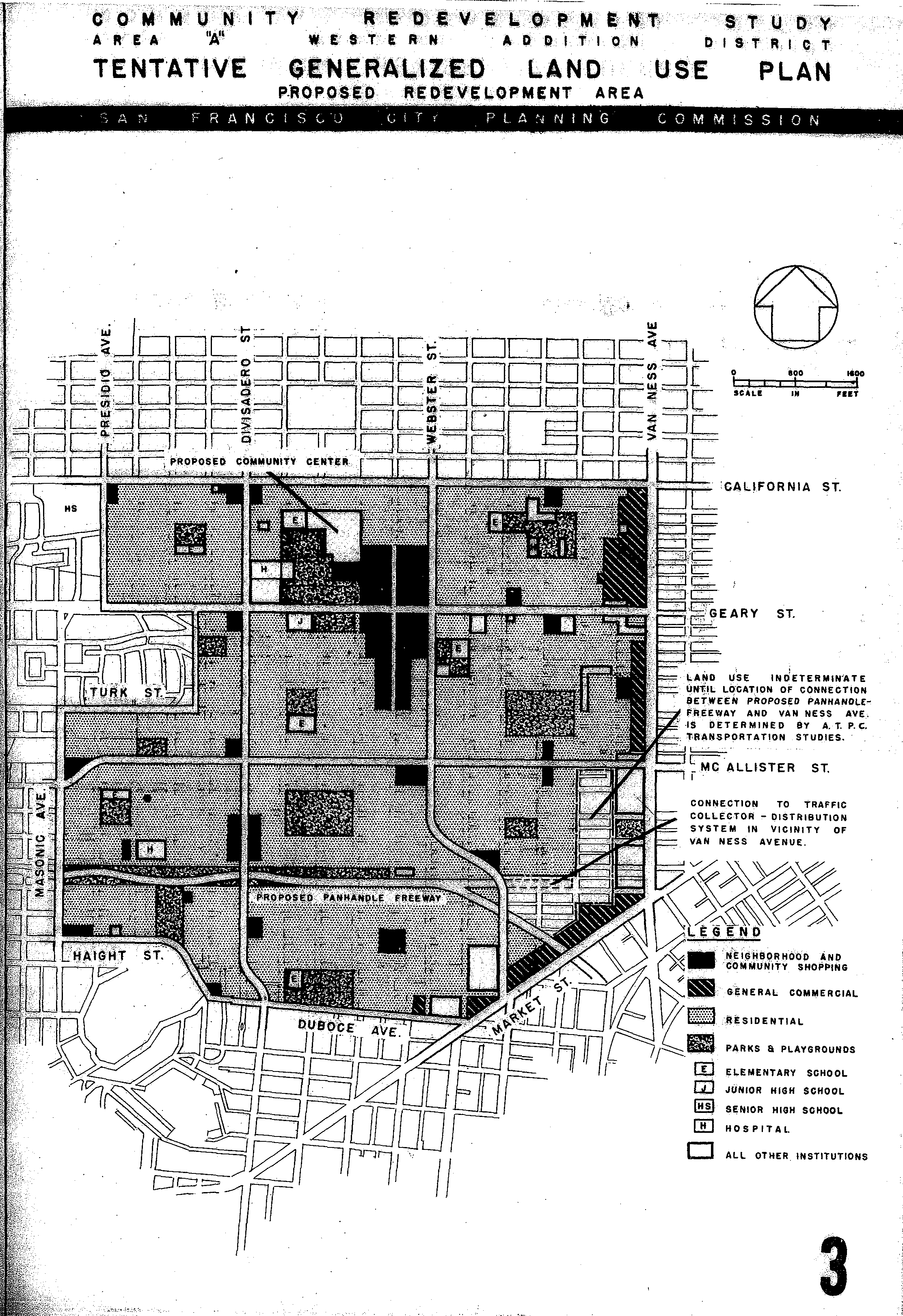
The city had been busy bulldozing large swathes of Western Addition since the 40s in the name of urban renewal, and combined with the divisive effects of the Bayshore Freeway, many citizens were losing their appetite for sacrificing neighborhoods for grand civic projects. One lesser-known part of the Panhandle plan is that it was envisioned as a complement to the would-be recreated version of Western Addition.
As contemporary Chronicle writer Harold Gilliam warned, the Panhandle planners’ calculations were once again blind to the social cost that the project would have on the nature of the city itself. (“Battle of the Panhandle’, March 29 1964, Chronicle, Harold Gilliam).
The Haight-Ashbury Neighborhood Council (HANC) was formed largely in reaction to the freeway plan, and in the early '60s began creating a coalition. It partnered with a growing number of local academics, like Art Bierman of San Francisco State University, to find more allies – students, local homeowners, artists, and other community organizations.Welch credits Susan Bierman (Art’s wife at the time) with spearheading the fight against the freeway project, and notes the prominence of women throughout the campaign.
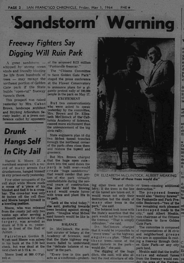
The growing environmental conservation movement also became an ally. For example, Dr. Elizabeth McClintock, of the California Academy of Sciences and Albert Meaking, both conservationists warned that the proposed freeway would disturb the ecological balance that had developed within the Panhandle’s growing urban forest. (‘Sandstorm Warning’, Chronicle, May 1, 1964)
An excerpt from the article where experts claimed that the freeway would not preserve the Panhandle trees, and instead invite environmental disaster. Via the San Francisco Public Library.
The San Francisco Examiner newspaper saw the project as a boon. Like a good portion of the Chronicle’s coverage in prior years, the paper was supportive of the project because of the overall benefits it intended to bring the city. In an introduction to series titled “Facts! and Fancy… The Panhandle Parkway Story”, the editors of the Examiner went into overdrive trying to rally support. It even published an article that highlighted the women of San Francisco who favored the project, in an apparent rebuke to Sue Bierman and other anti-freeway leaders.
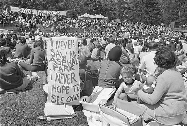
Meanwhile, The Citizens Committee to Save Golden Gate Park (CCTSGGP) coalesced 26 civic groups in opposition to the park. This group organized a protest in May 17, 1964 at the Polo Grounds where folk singer Malvina Reynolds sang a song composed for the occasion, called the "Cement Octopus".
The Examiner wrote, “[o]n the other side of the picture is the other morning newspaper which tried to rouse 100,000 people to go to Golden Gate Park and protest the plan.” Then later going on the report that a measly 5,000 only attended. An obvious jab at the Chronicle, whose editorial board by this point opposed the project. (Welch’s more favorable estimate puts the crowd at 50,000).
The Chronicle’s view was that the freeways would not be the boon that supporters thought it would be. The newspaper editorial board by that point foresaw a car-heavy future in which parking lots and on-ramps would dominate the landscape (“Battle of the Panhandle," March 29 1964, Chronicle, Harold Gilliam).
The May 17, 1964 anti-freeway protest. Via FoundSF.
The fight over whether or not the freeway was to be built was, according to Welch, “a struggle over the future of the city.” Calling the scale of the fight a first in neighborhood engagement and citywide activism, he stressed just how close the city was to building the freeway and how much effort was put into stopping it.
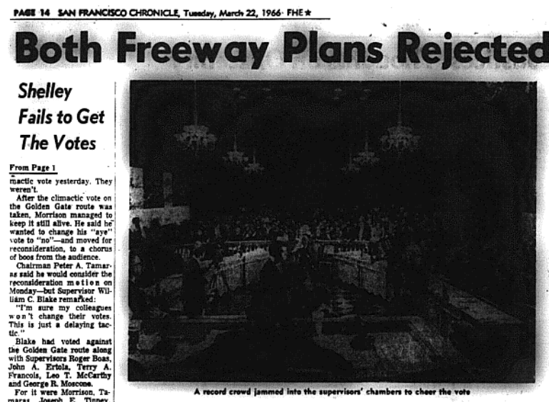
The Chronicle's coverage of supervisors defeating the full Panhandle-Golden Gate route. Via the San Francisco Public Library.
The denouement of the struggle came on March 21, 1966, when the Board of Supervisors voted, 6-5, to reject both the Panhandle and the complementary Golden Gate Freeway. A plaque now stands in a grove at the western end of the Panhandle commemorating the vote.
The Effects
While San Francisco has had strong neighborhood groups since the 1800s, activists in later decades have referenced the Panhandle battle as one of their inspirations for their efforts against other development plans. It showed that community protests could stop top-down planning.
It also redirected planning efforts. One obvious example was the second freeway revolt, in the 80s, which led to the dismantling of the Central Freeway section in Hayes Valley (and the premium real estate that is still being redeveloped today).
Lost in the story of the Freeway Revolt is the role it played in helping BART get institutional support. After the 1959 Supervisorial defeat of freeway plans, BART advocates got surplus Bay Bridge tolls allocated to the proposed transbay tube. After the 1961 vote against the Western Freeway, Mayor George Christopher and the influential Bay Area Council both endorsed the proposed BART system.
It is perhaps fitting that the latest possible transit solution for northwest San Francisco is a second BART tube, potentially going along Geary and extending down to the western edge of Golden Gate Park.
An even less appreciated element of the freeway story is its contribution to 1960s counterculture. The original draw of the neighborhood was “cheap rent for good apartments,” in the words of Hunter S. Thompson.
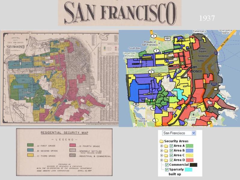
There were two main reasons why the apartments were cheap. One, going back to the 1930s, was “redlining.” Portions of the neighborhoods north and south of the Panhandle had been redlined for decades, meaning the US government wouldn’t support mortgages for home purchases in the area.
The racialist policy, which covered much of central San Francisco as well as other urban centers of the country, meant that wealthier white families were incentivized to move out to more suburban locales to buy homes. But racist policies and suburban neighborhood groups of the era forced non-whites (particularly black people) in the inner cities.
A 1937 Home Owners' Loan Corporation map of redlined areas in San Francisco, with the redlining around the Panhandle visible in the middle. Via T-Races.
For a time in the ‘40s and ‘50s, the Panhandle area experienced an increase in the African-American population, particularly as redevelopment bulldozers took out the core of the Western Addition and pushed people west.
In addition to previous redlining, the threat of the freeway development from the '50s through the '60s, and the expected demolitions and dislocations, also discouraged wealthier people from moving or staying. The cheap rents began attracting all manner of city dwellers, and further displacing the black population. The proximity to nearby universities, as today, put college students in the area.
The larger currents of the early '60s brought in the higher-profile types. We'll conclude this article (but not our coverage of the topic) with Hunter S. Thompson’s description of how the scene changed , from his 1968 essay, "The Hippies".
[I] was back in San Francisco, living in the Haight-Ashbury district, during 1964, 1965, and 1966. None of these moves was intentional in terms of time or place; they just seemed to happen. When I moved into the Haight-Ashbury, for instance, I’d never even heard that name. But I’d just been evicted from another place on three days’ notice, and the first cheap apartment I found was on Parnassus Street, a few blocks above Haight. At that time the bars on what is now called “the street” were predominantly Negro. Nobody had ever heard the word “hippie,” and all the live music was Charlie Parker-type jazz….
It was also in 1965 that I began writing a book on the Hell’s Angels, a notorious gang of motorcycle outlaws who had plagued California for years, and the same kind of weird coincidence that jelled the whole hippie phenomenon also made the Hell’s Angels part of the scene.... The Angels went and thereby met a lot of people who were living in the Haight-Ashbury for the same reason I was (cheap rent for good apartments). People who lived two or three blocks from each other would never realize it until they met at some pre-hippie party. But suddenly everybody was living in the Haight-Ashbury, and this accidental unity took on a style of its own. All that it lacked was a label, and the San Francisco Chronicle quickly came up with one. These people were “hippies,” said the Chronicle, and, lo, the phenomenon was launched.
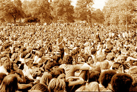
A Summer of Love photo in Golden Gate Park, 1967. Photographer unknown.
 A close-up of Avenue Drive, via SFCitizen, from this David Rumsey composite.