Austin residents hoping to catch a glimpse of today's eclipse may have to contend with overcast skies and potential weather disruptions, according to local forecasts. The morning's cloud cover is expected to thin out during the day, offering a chance for a clearer viewing of the celestial event. However, light rain might affect areas east of the interstate and into eastern counties in the early part of the afternoon, as reported by KXAN.
Mostly cloudy skies are expected today (😔) with a chance for showers & thunderstorms. Some strong to severe storms will be possible in the far northeastern portion of the area mid-afternoon and evening. Multiple rounds of storms are expected through at least Tuesday night. #txwx pic.twitter.com/UpfQkYfDQg
— NWS Austin/San Antonio (@NWSSanAntonio) April 8, 2024
Adding to the day's anticipation, severe weather is on the horizon post-eclipse. Following the eclipse's conclusion, "the beginning of an increasing chance of rain and, eventually, thunderstorms," is expected to roll in from the desert southwest. As per the National Weather Service, a high near 82 degrees with showers and thunderstorms likely after 1 p.m., carrying a 70% chance of precipitation. Winds could be gusting as high as 20 mph tonight, perhaps obscuring the skies even further with patchy fog after 1 a.m.
Stormy conditions are expected to ramp up during the late afternoon, with "an increasing threat of showers and thunderstorms after 3 p.m. into the evening," as cited by KXAN. The forecast includes severe thunderstorms capable of producing hail measuring two inches in diameter—the size of a hen egg—and wind gusts of 58+ mph. Isolated tornadoes are also a possibility, especially in areas such as Lampasas, Milam, and Williamson Counties.
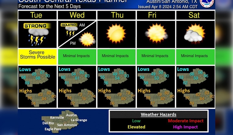
The troublesome weather won't cease with the eclipse's end. Tuesday's conditions are slated to worsen with a 90% chance of showers and thunderstorms, as noted by KXAN. Areas currently at a Slight (Category 2) risk level will be upgraded to Enhanced (Category 3) by tomorrow. While Wednesday may bring a break in the storms with only a 20% chance of rain predicted and cooler temperatures, the rest of the week looks to heat up with temperatures possibly reaching the mid-80s by Sunday.
Austin is in for a warmer and wetter period ahead according to the Climate Prediction Center, which forecasts above-normal warmth and precipitation from the 15th to the 21st. Rainfall amounts between a tenth to a quarter of an inch are expected today, with higher amounts possible where thunderstorms occur. The midweek respite will present mostly clear skies and brisk northwest winds, cooling to low to mid-70s on Wednesday night.


