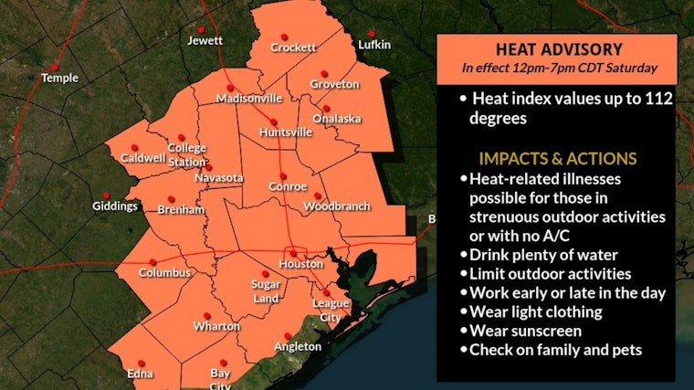
Houstonians brace yourselves, the weather gods aren't giving us a break any time soon. The National Weather Service foresees a scorching week ahead with mostly sunny skies and highs flirting with the mid-90s. To add to the discomfort, the heat index will be playing in the major leagues, reaching values as eye-watering as 112.
While we navigate the blistering days and steamy nights with lows stubbornly parked around the 80s, there's a fickle chance of showers and thunderstorms—mostly post-lunchtime. "A 30 percent chance of showers and thunderstorms, mainly after 1pm," predicts the NWS, ensuring our afternoons remain a lottery of sunshine, and potential downpours.
Further insight by The Storm Prediction Center meanwhile, details a "slight risk" of severe thunderstorms tracking to our northeast, though Houston seems likely to sidestep the worst of these tempestuous events. Strong winds, unwelcome hail, and damn disruptive gusts are on the cards for the eastern states.
Now, if you're hoping for a silver lining, keep those hopes low. As per a blunter summary presented by NWS Houston's social media update, "Enjoying the summer sizzle? Loathing the summer sizzle? Regardless of which team you're on, the high heat and humidity is here to stay."
Enjoying the summer sizzle? Loathing the summer sizzle? Regardless of which team you're on, the high heat and humidity is here to stay. If you don't like it, send your complaints to the stubborn upper level ridge of high pressure overhead. #HOUwx #BCSwx #GLSwx #TXwx pic.X.com/JwavAM8Z1G
— NWS Houston (@NWSHouston) June 29, 2024
Looking ahead to our very own star-spangled Independence Day, it's mostly sunny with yet again, a high near 95. Nightfall doesn't offer much salvation either, as lows will hover stubbornly around the 80-degree mark. Whether you're planning barbecues or banking on outdoor festivities, it might be prudent to keep water and shade at arm's reach.


-1.webp?w=160&h=400&fit=crop&crop=edges)
