Austin residents can expect a shift in weather conditions as the last day of scattered showers segues into a prolonged stretch of heat. Forecasters at the National Weather Service predict "a slight chance of showers and thunderstorms between 1 pm and 4 pm" today, with a heat index reaching as high as 100 degrees. This comes ahead of a weekend where "mostly sunny" skies and rising temperatures, potentially up to 94 degrees, are anticipated, according to the National Weather Service.
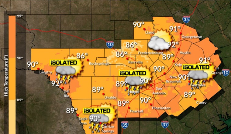
Isolated to widely scattered showers and thunderstorms are forecast today. High temperatures in the upper 80s to low 90s are forecast. pic.twitter.com/gqjYmjeTzW
— NWS Austin/San Antonio (@NWSSanAntonio) June 21, 2024
KXAN reports, that under the mix of sun and clouds today, Central Texas should brace for "upper 80s to low 90s" high temperatures. "Today will be our last day of notable rain chances before our pattern turns hotter and drier this weekend," says KXAN, noting that the scattered rain may bring tropical downpours contributing "0.1″-0.5″ of rain" in some areas.
Looking forward, the weather outlook does not suggest a reprieve from the heat. As per the National Weather Service, "Sunny" conditions with a high pushing to a sweltering "96 degrees" are poised to dominate Sunday's forecast, and "Mostly sunny" conditions with highs nearing the '90s will continue into the early week.
With the heat dome anticipated to shift toward the Desert Southwest early next week, as KXAN explains, any "possible tropical development in the Gulf" will likely be deflected away from Texas. The arrival of the heat dome signifies drying skies and intensifying heat, concurrently shutting down rain chances. Texans now face a brewing cauldron of temperatures with Wednesday and Thursday forecasted highs of 98 and 99 degrees.


