As Houston braces for a shift in weather, residents should prepare for potentially severe conditions in the coming days. According to the National Weather Service, today Houston can expect mostly cloudy skies with a high near 83 degrees and a south wind reaching up to 20 mph. The night will bring cloudy conditions with temperatures dropping to around 70 degrees and winds continuing to gust as high as 25 mph. The NWS warns that this is just the onset of a wet weather pattern stretching through the weekend, marked by increased humidity and warmer temperatures above the 80s, as noted in their forecast update.
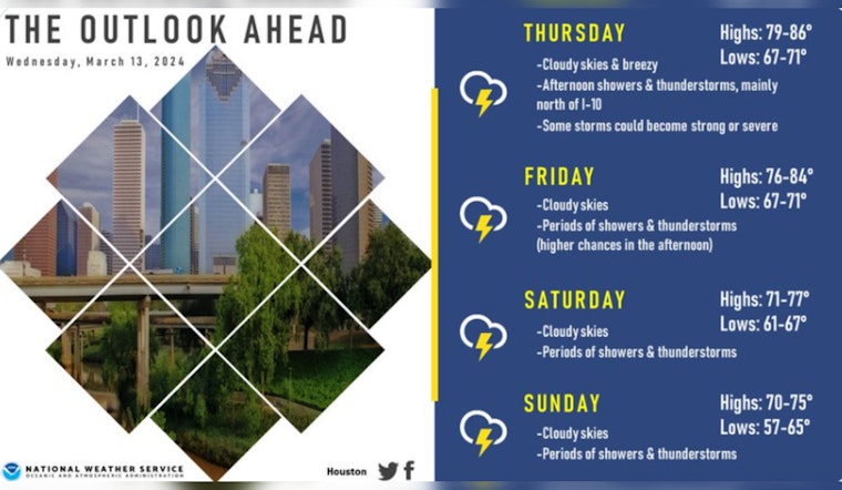
Thursday is set to bring mostly cloudy skies and breezy conditions with highs approaching 84 degrees, however it's not just the heat Houstonians should be wary of come nightfall, a 20 percent chance of showers and thunderstorms is on the horizon after 8 pm, the gusts may get as high as 25 mph, leading into a higher likelihood of showers and thunderstorms on Friday with a 60 percent chance of precipitation after 2 pm the forecast suggests a similar pattern for Saturday and rolling into Sunday with a 50 percent chance of storms throughout the day according to NWS Houston.
Meanwhile, the Storm Prediction Center has issued an enhanced risk of severe thunderstorms starting Thursday for regions beyond Houston, extending from southeast Oklahoma into western Arkansas, and southwest Missouri. "Strong to severe thunderstorms are possible across a large area from the Middle Mississippi Valley into eastern Oklahoma, East Texas, and the Lower Mississippi Valley," the SPC advises, indicating the highest threat zone sprawling from southeast Oklahoma into western Arkansas, where residents should stay vigilant of weather developments. This information was produced by the NWS Storm Prediction Center.
The weather scenario for Houston is complicated by the presence of a surface low over the NE/IA/MO border with an extended cold front across central OK and TX; dewpoints in the mid to upper 60s over east TX are expected to fuel storms, thunderstorms could erupt from early morning through late afternoon, and early evening across the warm sector as the day heats up, with the possibility of hail and damaging gusts especially near the cold fronts. "Some strong to severe storms are possible, particularly in the corridor from northern MO into the Arklatex," notes the Storm Prediction Center.
For the most immediate updates, NWS Houston advises citizens to "be weather alert and prepared," as they announced in their social media account on X to notify the public of the upcoming shifts in weather. With thunderstorms likely to prevail into the weekend, preparations to safeguard against the unpredictable are as essential as ever.
Good morning Southeast TX!
— NWS Houston (@NWSHouston) March 13, 2024
Today will be warmer and humid with highs in the 80s.
Thursday will be the start of a wet weather pattern that is to persist through the weekend.
Be weather alert and prepared ☔️⛈️#HOUwx #BCSwx #GLSwx #TXwx pic.twitter.com/gwncuvDbCS


