Houston residents are bracing for a wave of potentially hazardous weather as forecasts anticipate a mixed bag of conditions over the coming days. According to the National Weather Service, today brings mostly cloudy skies with highs reaching 82 degrees, accompanied by gusty southeastern winds that could peak at 25 mph.
The uncertainty, rolling in with the weekend, points toward breezier conditions and chances of precipitation on the horizon. Cloudy nights with lows lingering around the low 70s are expected, as southeast winds sustain their blow at 15 mph, gusting upwards of 30 mph. Come Saturday, the mercury is predicted to climb slightly higher to 85 degrees amidst mostly sunny skies and stronger winds. The breeze could turn forceful, ramping up to as high as 40 mph, sharpening the cue for vigilance among the locals.
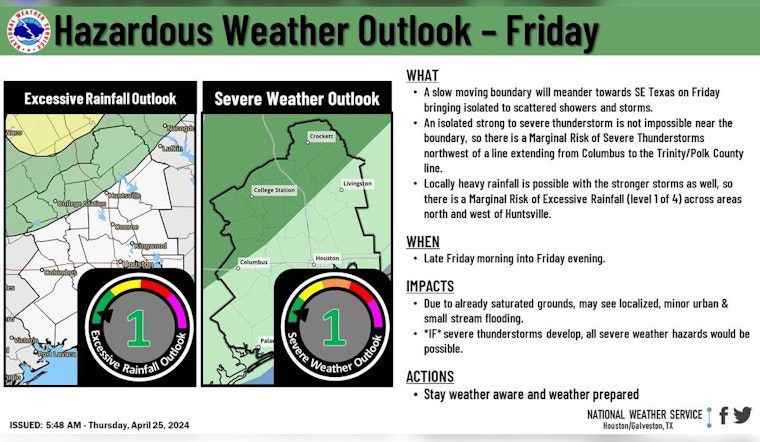
Checks on the city's weather pulse trickle through the week with updates of shifting patterns, and whispering promises of showers and thunderstorms. A post from the National Weather Service’s Houston account warns of a marginal risk for severe storms and locally heavy rainfall starting late Friday morning, a forecast that envelops Brazos Valley to Piney Woods in its reach. The week pivots on Sunday, teasing a 40 percent chance of rain and storms after 1 pm, amidst partly sunny conditions and high 84s.
A slow-moving boundary will approach SE Texas tomorrow bringing isolated to scattered showers and storms to the Brazos Valley to Piney Woods region. There is a Marginal risk of strong/severe storms and locally heavy rainfall late Friday morning into the evening.#HOUwx #TXwx pic.twitter.com/sYwA6Q85yr
— NWS Houston (@NWSHouston) April 25, 2024
The sky narrative unfolds further with the Storm Prediction Center chiming in on the potential for severe thunderstorms ascending from the southern Great Plains up to parts of Nebraska and Iowa. "An active severe weather day appears possible on Friday from parts of Nebraska and Iowa southward into parts of the southern Great Plains and Ozarks. A few tornadoes (possibly strong), large to very large hail, and damaging winds will all be possible".


