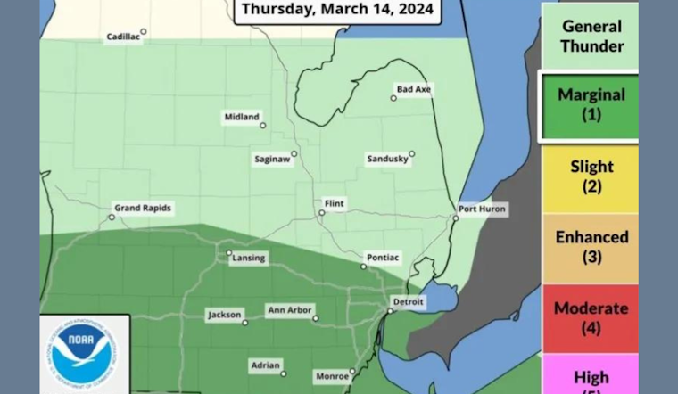
Residents of Southeast Michigan should brace for potential severe weather on Thursday, as forecasters warn of thunderstorms and winds reaching 60 mph. According to WWJ, the National Weather Service (NWS) has indicated that especially the area south of Pontiac and the M-59 corridor could face a "marginal risk" for damaging winds, hail of up to an inch in diameter, and possibly even an isolated tornado.
The Detroit News emphasizes that along with periodic rain showers, the Metro Detroit area might experience thunderstorms through the evening, with residents south of Interstate 96 being particularly vulnerable to severe weather, meteorologist Trent Frey commented, "If that was the case, there would be a chance for tornadoes, but some of the recent weather models have come in and it doesn't look like that's much of a possibility anymore," Trent Frey told The Detroit News. This comes after near-record temperatures in the region, with Wednesday's peak tying the record for March 13 set back in 1874.
In addition to strong winds and hail, Mlive includes a statement from the Storm Prediction Center, which maintains a "marginal risk" rating for severe thunderstorms along the I-94 corridor southward, acknowledging a 2% chance of an isolated tornado due to wind shift and shear. Their commentary reminds readers, "Never trust a warm front," about the deceptive nature of surface conditions that might not appear threatening yet can produce severe weather above ground level.
The threat of storms however is tempered somewhat by mlive's meteorological perspective that suggests the northeast wind coming off Lake Huron could push any unstable air southward, reducing the risk of severe storms in Michigan, the weather outlook for early next week promises a return to more typical cold with AccuWeather meteorologist Brian Thompson telling WWJ, "We could even see some flurries, maybe even a couple of snow showers," expect a shift towards lower temperatures after the weekend.


