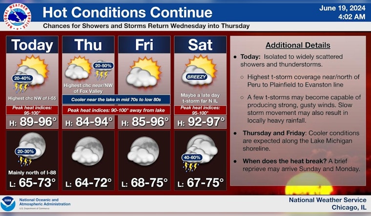
Chicagoans are bracing for another wave of summer heat, with forecasts predicting temperatures soaring into the mid-90s. In a statement obtained by the National Weather Service, there's a "20 percent chance of showers and thunderstorms after 1pm" on Juneteenth, with possible "heat index values as high as 97." Meanwhile, tonight could see a "patchy fog after 3am" with lows lingering around 68 degrees.
The outlook also warns of "Limited Excessive Heat Risk" for the area, with the added possibility of thunderstorms, particularly "near and north of a Peru to Aurora to Evan Ale" line. While severe weather and flooding seem unlikely, the Hazardous Weather Outlook report notes that thunderstorms "may produce locally heavy downpours and gusty winds." For those spending time on Lake Michigan, a "Limited Thunderstorm Risk" remains in place, as indicated by the same outlet.
General storm motion is expected to move towards the northeast at 20-25 mph. The upcoming days until Tuesday will uphold this pattern, with thunderstorm risks persisting alongside the relentless heat. Despite these predictions, the nearshore areas of Lake Michigan might feel some relief from the scorching conditions, where "cooler conditions will prevail near the lake," according to a post from the National Weather Service Chicago's X feed.
Besides the chance of thunderstorms and high heat indices, individuals in Chicago can expect varying conditions throughout the week. Thunderstorm chances will continue intermittently through Saturday, and while the heat will be palpable, current models do not foresee critical temperatures that could trigger more severe safety alerts. Despite this "Limited Excessive Heat Risk," locals are advised to stay hydrated, seek shade during peak heat hours, and remain vigilant of the ever-changing weather patterns across the city.


