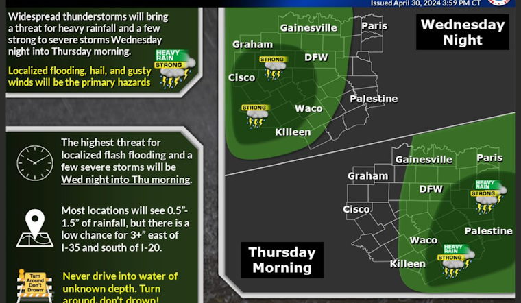
Dallas is bracing for a spell of rough weather, with a forecast that promises a mix of thunderstorms and rainfall starting this afternoon and ramping up tonight. According to the National Weather Service, there's a 20 percent chance of showers and thunderstorms after 4 pm today in Dallas, with partly sunny skies and a high near 85 degrees. But tonight, storm clouds are gonna roll in, bringing a 70 percent likelihood of showers and thunderstorms mainly after 1 am, with potential new rainfall between a half and three-quarters of an inch.
The situation is more severe according to the Hazardous Weather Outlook released, with "damaging wind gusts and flash flooding" cited as the primary concerns for today and tonight; "lower threat" comes from the possibilities of large hail and tornadoes, with all of North and Central Texas on alert, the Hazardous Weather Outlook warns. The forecast continues to be dicey through the week, with the highest threat of severe storms shifting to Thursday evening in Western North Texas, while daily chances of thunderstorms linger through to the weekend.
Scattered thunderstorms aren't a stranger to the Lone Star State this time of year, but residents should take heed: Thursday's daytime will likely see more thunderstorms, particularly before 10 am, and while the sun may make intermittent guest appearances, the high temperature will hover near 82 degrees. The volatility continues into the night with a 50% chance of thunderstorms. Friday and Saturday repeat the pattern—partly sunny days followed by mostly cloudy nights laden with thunderstorm threats, outlined by the same National Weather Service’s Dallas forecast.
The onslaught continues with the workweek; Sunday and Monday won't let up with a 40% chance of rain and thunderstorms bleeding into each other, and though the skies clear a tad on Tuesday, with a high near 90, the reprieve may be short-lived—the Hazardous Weather Outlook implies the storm risks are far from over. Those in the affected areas are advised to stay updated on weather alerts and be prepared for severe conditions that could prompt timely reports of severe weather and flooding deeply appreciated by meteorologists on the ground.


