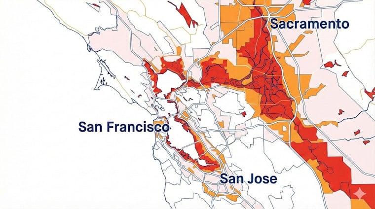
NOAA's latest 10-foot sea level scenario all but erases the line between some Bay Area waterfront neighborhoods and the bay itself. On the agency's interactive map, wide bands of the Atlantic, Gulf and Pacific coasts slip under simulated water, turning long-term climate projections into block-by-block visuals. For locals, that means low-lying streets around the Bay Area now sit in the same red-highlighted company as parts of New York City and stretches of Florida beach towns.
NOAA’s 10-foot viewer and what it does
NOAA's Sea Level Rise Viewer lets users dial up scenarios from current high tide to 10 feet above it, then layer on photo simulations, estimated water depths and socio-economic data. The agency stresses that this is a screening-level planning tool, not a surveyor’s map: it does not factor in shoreline erosion, land subsidence or future buildings and levees. In other words, it is meant to show the scale and pattern of exposure, not to fix a legal property line. The tool and its methods are laid out by NOAA.
Which cities show up on the map
Turn the 10-foot layer on and the Pacific Northwest sees partial flooding in places like Seattle and Port Townsend, along with stretches of the Oregon coast. In California, the viewer picks up vulnerable areas in Crescent City, low-lying parts of the Bay Area and sections of Southern California. On the East Coast, the projection chews into much of Maine's shoreline, tags Boston-area neighborhoods, and pushes water into parts of Manhattan, Brooklyn, Queens and Staten Island. Farther south, the map lights up the Southeast and Gulf coasts, from Charleston and the Carolinas down through Florida's barrier islands and beaches, as some of the most heavily affected zones, according to Newsweek.
Expert warning: timelines and consequences
Randall Parkinson, a coastal geologist and research associate professor at Florida International University, described a 10-foot rise in sea level as "catastrophic" in comments to Newsweek. He said a seven-foot rise by 2100 is "very likely," and that a 10-foot rise would "surely" follow roughly two decades later. In his view, the story is not just drowned streets but buried systems: stormwater pipes and sewers that depend on gravity, plus rising groundwater and saltwater that can push far inland and contaminate wells. His long record of coastal research and vulnerability assessments is outlined in his profile at Florida International University.
Hazardous sites and environmental justice
A peer-reviewed study in Nature Communications finds that more than 5,500 hazardous facilities in U.S. coastal states and Puerto Rico are projected to face coastal flooding risk by 2100, with nearly 3,800 already at risk by 2050 under high-emissions scenarios. The facilities include wastewater treatment plants, refineries, fossil-fuel ports, industrial sites and former defense properties. The analysis shows the threat clustering in states such as Florida, New Jersey, California, Louisiana, New York, Massachusetts and Texas, and it flags that the resulting harms are likely to fall hardest on low-income communities and neighborhoods of color, compounding public-health burdens and cleanup challenges.
What this would mean for neighborhoods
In the Bay Area, the 10-foot scenario pulls low-lying corridors, tidal marshes and filled former tidelands into the water, suggesting flooded streets and serious trouble for gravity-fed drainage and sewer lines. Rising groundwater that tracks with sea level can produce inland flooding and saltwater intrusion that salinizes wells and eats away at buried pipes and building foundations, effects that Parkinson has documented in his work. These neighborhood-scale scenarios show up in NOAA's mapping tools and associated technical documentation and are echoed in Parkinson's research summary at Florida International University.
Planning choices: defend, retrofit or retreat
Confronted with maps like these, city and county officials face a blunt menu of choices: build up defenses, harden and retrofit critical infrastructure, or pursue some form of managed retreat that can include voluntary property buyouts. Federal hazard-mitigation dollars can help pay for buyouts in flood-prone areas, although experts note that these programs can be slow to roll out, limited in scope and uneven in who they reach. Several states and local governments are now studying voluntary retreat options and equity-focused frameworks as part of long-range resilience plans. Overviews of property buyouts and equity considerations are compiled by Pew, and local coverage of pilot efforts is available from WBUR.
What to watch next
Scientists and planners underline that cutting carbon emissions is still the only way to slow long-term sea-level rise, even as communities race to manage the near-term flooding already mapped out. Taken together, NOAA's visualizations and the peer-reviewed work on hazardous facilities make one thing uncomfortably clear: the areas at risk are largely known, and choices about whether to defend, retrofit or retreat will decide who bears the costs and who absorbs the damage. For a broader look at the public-health stakes and policy angles, see the analysis in Nature Communications.


