In the coming days, developing Hurricane Hilary is expected to bring a significant surge of monsoonal and tropical moisture to San Diego County, with widespread heavy rainfall forecasted for Sunday into Monday, and flash flooding potential in the mountains and deserts, according to ABC 10 News' reporting from National Weather Service (NWS). The residual moisture may maintain an active monsoon pattern through at least the middle of next week, with afternoon and evening thunderstorms possible in the mountains, deserts, and inland valleys.
A weak low-pressure system moving to near the central California coast may bring drier southwest flow aloft through Friday and cooler high temperatures for the coast and valleys Thursday, spreading into the mountains and deserts on Friday. The marine layer, expected to be near 1,200 to 1,500 feet deep, will bring night and morning coastal low clouds further inland into the far western valleys of San Diego County.
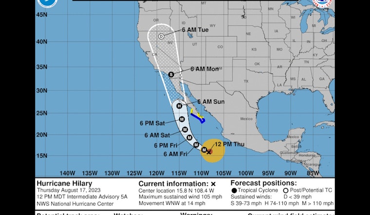
The NWS forecasts a significant moisture surge for Friday night into Saturday with strong southeast winds across the deserts and mountains, along with more clouds, much cooler high temperatures for inland areas, and increased chances for precipitation for the mountains and deserts. In its rapid intensification, Tropical Storm Hilary became a hurricane on Thursday and is predicted to develop into a major hurricane as it moves northward off the Pacific coast of southern Baja, as per the NWS San Diego's X post.
And with that, Hilary is now a hurricane. Note: the track forecast was not updated with this advisory. Curious on how to interpret this product? Check out this video from the National Hurricane Center: https://t.co/BXWc7dshIA pic.twitter.com/J9Pdya1NKX
— NWS San Diego (@NWSSanDiego) August 17, 2023
Regardless of the exact track, Hurricane Hilary is likely to bring a substantial surge of moisture to portions of southern California, with a high potential for heavy rainfall and flash flooding, particularly in the lower deserts and adjacent mountains. The latest forecast has rainfall through Monday exceeding 5 inches for the lower deserts and adjacent mountains, with 5 to 10 inches on portions of the east slopes of the mountains. This moisture surge is expected to be slow to dissipate, with an active monsoon pattern persisting through at least the middle of next week.
The NWS National Hurricane Center's latest track forecast has the storm's trajectory turning north toward Southern California by Friday and shifting again toward Baja California over the weekend, likely as a post-tropical storm. By Sunday or Monday, San Diego County is expected to feel the impact of Hurricane Hilary, experiencing heavy rainfall and gusty winds, though the extent of the storm's impact is not yet determined. The chance of showers could linger through next week, as another NBC San Diego article suggested.
The current cone from the NWS National Hurricane Center accounts for uncertainty, estimating the possibility of the tropical storm switching direction or wind speeds in the days ahead. If the estimates are accurate, Hilary could be the first tropical storm to impact San Diego County since Tropical Storm Kay in September 2022, as NBC San Diego reported.
A south-southeast swell produced by Tropical Cyclone Hilary has the potential to bring high surf to south-facing beaches Sunday and Monday, as well as the chance of lightning late Saturday through Monday, per the NWS. Residents and visitors in San Diego County are advised to stay updated on the latest forecasts and advisories as Hurricane Hilary moves closer.


