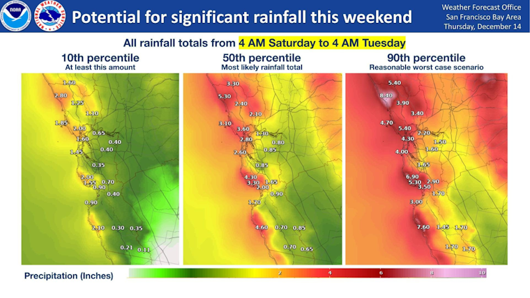
The Bay Area is bracing for a rainy weekend as a low pressure system is set to bring moisture to Northern California. According to the National Weather Service (NWS) Bay Area, the region could see various scenarios for rainfall totals across a 72-hour period from Saturday morning to Tuesday morning. The forecast predicts a high likelihood of at least an inch of rain across much of the region.
Rain is returning this weekend as a low pressure system approaches the region. Here's a look at different scenarios for rainfall totals across the region, for a 72 hour period from Saturday morning to Tuesday morning. #CAwx pic.twitter.com/qJ85nNqsgO
— NWS Bay Area 🌉 (@NWSBayArea) December 14, 2023
The Area Forecast Discussion by the National Weather Service in San Francisco anticipates warmer temperatures leading into the weekend, but the weather is expected to turn cooler and wet as the new system moves in. Before the rain begins, some coastal areas are concerned about minor flooding due to high tides. "Minor coastal flooding will be a concern again this morning around the San Francisco/San Pablo Bay as tidal levels are running about 1/2 to 3/4 foot above predictions," the discussion states.
Adding to the regional advisories, a Coastal Flood Advisory has been issued for parts of the San Francisco Bay Area. It is in effect from 11 AM to 2 PM PST Thursday due to expected minor flooding, particularly on the San Francisco Bay Shoreline and on the North Bay Shoreline, during which roads and parks might see isolated closures from high tides peaking at 6.64 feet.
Maritime advisories have also been released, with a Small Craft Advisory in place from 3 PM Friday to 3 AM PST Saturday, signaling the storm's approach. Winds are predicted to pick up beginning Friday and continue through the weekend, reaching southeast winds of 15 to 20 knots with gusts up to 25 knots expected. Mariners, especially those in smaller vessels, are warned of hazardous conditions during this time.
Residents can follow updates on the developing weather situation, including risks of thunderstorms and the exact path of the storm, from the NWS Bay Area's X post. The NWS also cautions that the unpredictable pattern of cut-off lows makes forecasting challenging, so those in the affected areas should stay informed as the situation progresses.


