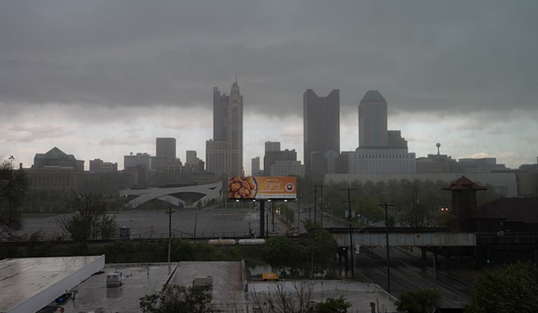
Ohioans are set to experience a shift from calm skies to a wetter regime as the National Weather Service (NWS) predicts widespread rain resulting from a moving storm system. According to the latest forecast discussion, residents in Columbus, Cincinnati, Wilmington, and surrounding areas will get one more day of dry weather courtesy of high pressure south of the region before precipitation takes hold.
Today promises to bring dry conditions with sporadic gusts of southwestern wind with a warming trend that could push temperatures into the low to mid-50s, the fallout of the surface ridge near the Appalachians that's the reigning climatic influencer at present. However, come tonight, a weakened storm system, once a closed mid-level low over northeast Oklahoma, will lay down a blanket of rain stretching through to Monday midday, Sunday's sunshine thereby throttled in anticipation of rain that could summate between one-half and three-quarters of an inch in liquid depth.
In the wake of this system, the area anticipates a continued wet spell into Tuesday when the cold front edges through, persisting the chance of rain, albeit with spotty distribution, the landscape steeped in the mistiness of day's dawn and sheets of rain expected, as per the National Weather Service outlook. Temperature profiles will throw mild airs with little flux from highs in the 50s to overnight lows in the 40s.
The upcoming days hint at a topsy-turvy configuration of overcast skies, episodic rainfall, and a potential nosedive into snowy confetti post-Tuesday as a cold snap takes hold, elements reflected in the persisting complexities of a west-southwest 500mb flow pattern and an amplifying upstream trough, this broader synoptic story narrated with careful precision by forecasters at the National Weather Service. The shift to colder conditions is so stark that Thursday may see many parts of the ILN County Warning Area battling to climb out from icy grasps mostly sub-freezing, with the northern stretches of the region likely rooted in lower to mid-20s, an arresting cold that invites a reminder to dress warmly and drive cautiously.
Air travel, too, is forewarned to encounter disruptions; aviation forecasts signal a shift from VFR to IFR and potentially LIFR conditions as rainclouds muscle in from the southwest post-04Z, the visibility kneecapped by incoming precipitation. Pilots may continue navigating through pockets of IFR ceilings and MVFR to IFR visibilities as the workweek unfolds, a testament to the atmospheric tumult scripted by this advancing December weather front.


