Jacksonville residents should brace themselves for a high chance of showers and thunderstorms today, per the National Weather Service's latest update. The forecast, released early this morning, suggests that showers are likely, possibly accompanied by a thunderstorm before 11 a.m., with more scattered showers and thunderstorms to follow into the afternoon. The day is expected to be mostly cloudy with southerly breezes reaching speeds up to 16 mph, and gusts potentially as high as 24 mph. A detailed NWS' forecast anticipates new rainfall amounts between a tenth and a quarter of an inch, though higher amounts could occur during thunderstorms.
In the evening, there's a lesser chance of precipitation, with a 30 percent probability of showers and thunderstorms before 11 p.m., mostly cloudy skies, and lows around 67 degrees. Southeast winds will blow at 6 to 11 mph, with gusts that may reach up to 17 mph, suggesting a milder night for those in the Jacksonville area.
Looking ahead to Tuesday, the forecast calls for a slight chance of showers in the morning which increases to a chance of showers and thunderstorms post-2 p.m. The day is set to reveal mostly sunny conditions with high temperatures pushing to near 85 degrees. A southwest wind will keep things moderately breezy at 7 to 11 mph, gusting up to 17 mph. The chance of precipitation stands at 40 percent. By Tuesday night, the potential for showers and thunderstorms drops again to 30 percent before tapering off by 8 p.m., giving way to clearer skies and a low of around 66 degrees.
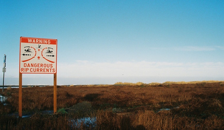
A rip current statement is also in effect for Northeast Florida beaches until late tonight, as dangerous rip currents pose a threat to beachgoers. According to the National Weather Service warning, "Rip currents can sweep even the best swimmers away from shore into deeper water." Caution is advised, with recommendations to swim near lifeguards, stay calm and afloat if caught in a current, and to follow the shoreline if possible. For those unable to escape, signaling or calling for help is recommended. The areas impacted include Coastal Nassau, Coastal Duval, Coastal Flagler, Northeast Coastal St. Johns, and Southeast Coastal St. Johns.
With safety in mind, residents and visitors to the beaches should heed these warnings and take necessary precautions as they plan their activities. For the latest weather updates and advisories, individuals are encouraged to keep monitoring reports from the National Weather Service.


