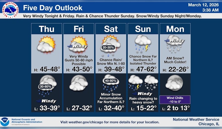
Mostly clear skies hang over Chicago this morning, with temperatures running near 30°F. Sunshine should nudge highs into the mid 40s Thursday, but the real action waits until after dark. Late tonight into Friday, a burst of very strong winds is expected to flip the script on an otherwise calm day. A High Wind Watch covers parts of northeast Illinois and northwest Indiana, with the strongest gusts expected Friday morning into early afternoon. Bottom line: plan on a windy Friday that could disrupt travel and outdoor plans.
What To Expect Tonight And Friday
Rain showers are likely after 7 p.m. Thursday, with little accumulation, but the wind will not be so subtle. Overnight, south-southwest winds will increase to 10–30 mph, with gusts up to 55 mph by early Friday. Friday stays blustery, with west winds of 25–35 mph and gusts near 60 mph possible, especially during the morning commute. Forecasters expect the most powerful gusts between about 7 a.m. and 1 p.m. Friday. For detailed timing and any updated advisories, check NWS Chicago.
Commute And Travel
High-profile vehicles will have a rough go of it, and drivers should be ready for possible delays on major roads and at airports Friday morning. Downed branches and scattered power outages are on the table. Along the lakefront, boaters should pay close attention to gale warnings and small-craft advisories as waves and winds build. Transit riders should budget extra time and check for alerts before heading out, and flyers could see ground delays tied to the gusty conditions. Keep tabs on local advisories and route conditions throughout the day.
Safety Tips
Tonight is the time to batten things down. Secure patio furniture, trash cans, and any loose objects, and bring pets and plants indoors if possible. If you have to drive in the thick of the gusts, ease off the gas, avoid passing high-profile trucks, and steer clear of downed lines or tree debris. Charge your phones, have flashlights ready in case the lights go out, and consider checking on elderly neighbors who might need a hand. If winds appear especially strong in your area, it is smart to delay nonessential travel until conditions settle Friday evening.
Looking Ahead
Winds back off Friday night, but the pattern stays active into the weekend. Saturday carries a slight chance of afternoon snow showers. Sunday brings a period of rain and snow showers, with an elevated storm risk and milder temperatures. A colder air mass then moves in Sunday night into Monday, with accumulating snow likely in parts of the region and highs only in the 20s on Monday. Wind chills could dip below zero early next week, so keep checking the forecast if you have weekend plans or outdoor events lined up.


