On April 1, 2026, Avondale Estates finally cut the ribbon on a long-planned remake of its downtown stretch of U.S. 278. What had been a five-lane highway slicing through town is now a three-lane main street with space for walking, biking and calmer traffic. City leaders marked the moment at a ceremony in Dewey Brown Plaza and spotlighted the project during the State of the City address.
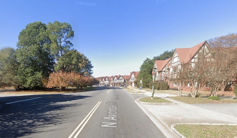
The North Avondale Complete Street Project rebuilt roughly 1.15 miles of North Avondale Road/East College Avenue. The work added a 10-foot multimodal path, upgraded traffic signals, a center median, landscape buffers, new pedestrian and bike crossings, and full repaving and re-striping. The revamped corridor runs from Sam’s Crossing near MARTA’s Avondale station east through downtown to Ashton Place, and construction took about 20 months, according to Urbanize Atlanta.
Funding, schedule and project record
Regional planning records list the project as GDOT PI 0015071 in the Atlanta Regional Commission’s transportation improvement program, with limits from Ashton Place to Sams Crossing. The Atlanta Regional Commission marks the work as authorized and documents those limits. City planning materials that accompany an update to the Downtown Master Plan describe the street changes as central to activating the Town Green and nearby blocks. Related City of Avondale Estates documents lay out the timeline and local context, while federal committee materials list roughly $1.98 million for a North Avondale Complete Streets line item on Congress.gov.
Ceremony and local reaction
The city held a ribbon-cutting at Dewey Brown Plaza on April 1, followed by a walk to the State of the City program at the Avon Theater, according to City of Avondale Estates event materials. Those materials describe the short procession from the plaza to the theater, and local coverage noted a comedy set by Emily Holden and a mini parade led by the Wasted Potential Brass Band. Ahead of all that fanfare, business boosters had warned in 2024 that construction would be disruptive, but they argued the work was needed to draw more foot traffic downtown, according to Downtown Development Authority minutes.
What it means for a walkable downtown
City planning materials frame the project as a way to stitch nearby neighborhoods to the Town Green and make downtown a place where people can “park once” and stroll between shops and restaurants. The Downtown Master Plan RFP calls the street redesign a central step toward a cohesive, multimodal downtown. During construction, the Downtown Development Authority rolled out micro-grants and marketing support to help small businesses handle the disruption. Officials say the new trees, curbside buffers and wider paths are intended to support new retail and restaurant activity in the corridor over time, a strategy reflected in Downtown Development Authority communications and city planning documents.
For residents, the near-term shift is straightforward: calmer traffic, safer crossings and an easier walk from the MARTA station into town. City leaders describe the overhaul as one part of a broader regional effort to reclaim busy state highways as people-friendly main streets.


