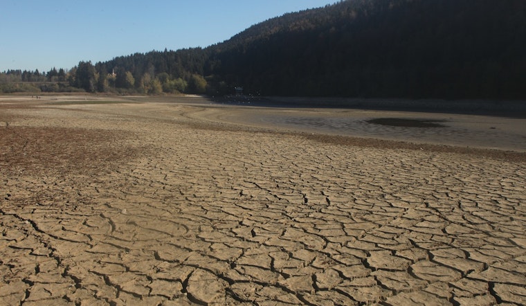
South Louisiana’s spring is starting off bone dry. The latest drought map shows extreme conditions tightening their grip on Terrebonne and Lafourche parishes, leaving farmers, marsh managers and coastal communities staring down a serious water shortage just as planting season and the seafood hustle kick into gear.
What’s On The Map
The U.S. Drought Monitor’s weekly update (map released April 2, data valid March 31) now paints most of Terrebonne Parish and broad stretches of Lafourche in extreme drought, or D3 territory. Severe drought has also crept north toward the I-10 and I-12 corridor and into parts of the North Shore. National analysts flagged widespread degradations across Louisiana, along with unusually warm weekly temperatures, roughly 3 to more than 15 degrees above normal, that helped deepen the moisture deficit, according to the U.S. Drought Monitor.
Rainfall Shortage And Heat
Climate records from the National Weather Service show New Orleans has seen about 9.44 inches of precipitation since January 1, which is roughly 5.20 inches short of the 1991 to 2020 normal of 14.64 inches, according to NWS New Orleans. The Louisiana Drought Team reports that more than 80% of the state is now in drought and that nearly one quarter is stuck in extreme drought, and short-range forecasts are only offering about 1 to 2 inches of rain in spots this week, not nearly enough to chip away at the backlog of dryness, per Louisiana Farm Bureau News.
Local Impacts: Planting, Fires And Seafood
For growers and coastal communities, the timing could hardly be worse. “Planting season could be impacted,” warned Julie Lesko, a senior hydrologist with the National Weather Service, who added that it will take multiple widespread soaking events to head off bigger problems later this spring, as reported by WVUE/FOX 8. On top of that, marsh fires and unusually low wetlands near Bayou Gauche and Houma have already been reported, raising alarms about air quality and dangerous fog on nearby roads, according to Axios New Orleans.
What To Watch Next
The next U.S. Drought Monitor update is set for Thursday, April 9, and forecasters will be watching to see whether early April rain chances put even a dent in the map. Analysts caution that it will take several weeks of steady, soaking rainfall, not a single light event, to pull parishes out of extreme drought, according to the U.S. Drought Monitor. In the meantime, agencies and local forecasters are urging residents and growers to pay close attention to official updates and to follow conservation and safety guidance, as reported by WGNO.


