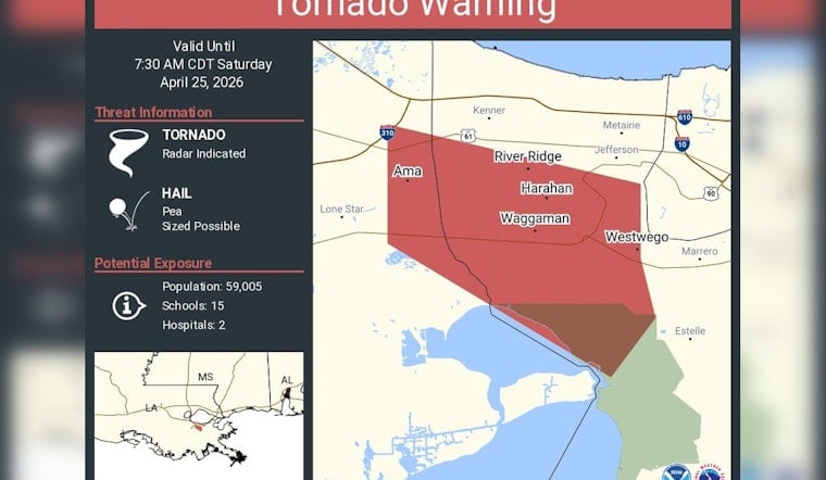
Early Saturday morning, phones buzzed and TV screens lit up across the New Orleans metro as a tornado warning snapped into effect for Kenner, River Ridge and Harahan, briefly hijacking regular programming with urgent coverage. The alert came as a line of showers and thunderstorms barreled southeast through the area at roughly 35 mph, and officials urged residents to hunker down indoors until the worst of the line moved through.
Local broadcaster WDSU described the line as tracking generally to the southeast at about 35 mph, with some showers and cells racing nearly west to east at 35 to 40 mph. The station’s First Warning Weather team cautioned that each storm cell could kick up wind gusts topping 40 mph, along with small hail and intense downpours. As reported by WDSU, the station stayed live on air with continuous updates in the early-morning hours.
What the National Weather Service Issued
The National Weather Service New Orleans/Baton Rouge office issued the tornado warning that explicitly listed Kenner, River Ridge and Harahan, using its standard language about radar-indicated rotation and the potential for damaging winds. The agency’s hazards page showed watches, warnings and advisories updating in real time as the line marched through the metro before sunrise. See the National Weather Service New Orleans/Baton Rouge site for official products and current maps.
Safety Steps and Quick Impacts
The NWS warning urged people to “TAKE COVER NOW!” and move to a basement or an interior room on the lowest floor, as far from windows as possible. Those in mobile homes or vehicles were told to get to sturdier shelter immediately. Forecasters also flagged a risk of isolated flash flooding as the line pushed into the metro around 6:45 to 7:00 a.m., according to the National Weather Service. Morning commuters were warned to brace for sudden heavy downpours and potential delays on area roads.
Threats Will Not Disappear Quickly
The Storm Prediction Center placed parts of the region under a marginal risk for additional severe storms on Sunday, suggesting the broader pattern could spin up another round of rough weather. Local forecasters told WDSU they would keep a close eye on conditions through the morning, and the station’s forecast called for afternoon highs in the mid 80s with a 30 to 40 percent chance of more showers. Residents are urged to keep multiple alert systems active, including phone notifications, weather radio or local TV, while this system lingers over the area, and to follow official NWS products for any fresh warnings.


