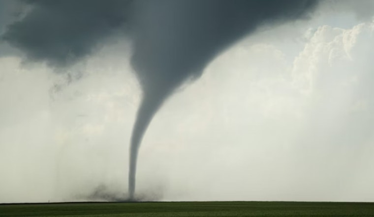
A quiet Tuesday afternoon turned serious for parts of Frio County when a tornado warning was issued for the Pearsall area as a line of severe storms marched east toward the San Antonio region. The National Weather Service reported a storm with radar-indicated rotation near Bluff, about 15 miles west of Pearsall, moving east at roughly 25 mph. The warning flagged the potential for a tornado and hail up to two inches in diameter, and residents were urged to move quickly into sturdy shelter.
What the National Weather Service Said
According to the National Weather Service, the tornado warning was issued by its Austin/San Antonio office and remained in effect until 4 p.m. Forecasters stated, "At 3:14 PM CDT a severe thunderstorm capable of producing a tornado was located near Bluff" and noted the storm was moving east at about 25 mph. The product warned that flying debris could be dangerous to anyone caught outdoors and that mobile homes were at particular risk if the storm intensified.
Timeline And Local Impact
As reported by MySA, the National Weather Service laid out a timeline that placed the storm near Bluff around 3:30 p.m., near Pearsall about 3:50 p.m., and near North Pearsall around 3:55 p.m. The warning covered portions of Frio County southwest of San Antonio and highlighted the risk of two-inch hail as the storm tracked east. Local roads and smaller communities inside the warning polygon were under the gun for large hail and damaging winds while the alert remained active.
Shelter Guidance
The message from forecasters was blunt. Residents in the warned area were told, "Take cover now! Move to a basement or an interior room on the lowest floor of a sturdy building. Avoid windows." The National Weather Service also warned that people in mobile homes, outdoors or in vehicles should head for the nearest substantial shelter and protect themselves from flying debris, per the National Weather Service. For anyone unsure whether they were inside the warning polygon, officials pointed to local TV coverage and NOAA Weather Radio for continuous updates.
What To Expect Next
Forecasters said the storms were part of a broader severe weather setup across South Central Texas that could also bring damaging wind gusts and large hail later in the evening, according to MySA. Local emergency officials typically urge drivers to avoid flooded roads and encourage residents to report dangerous conditions so responders can prioritize calls. This story will be updated as additional official statements and any damage reports become available.


