Austin residents are soaking up the sun with highs in the low 70s today, but they shouldn't get used to the warmth as a cold snap is around the corner, according to the National Weather Service. The forecast predicts a clear tonight with lows around 34, then a sharp turn as a dry Arctic cold front moves in, bringing high winds and colder temperatures.
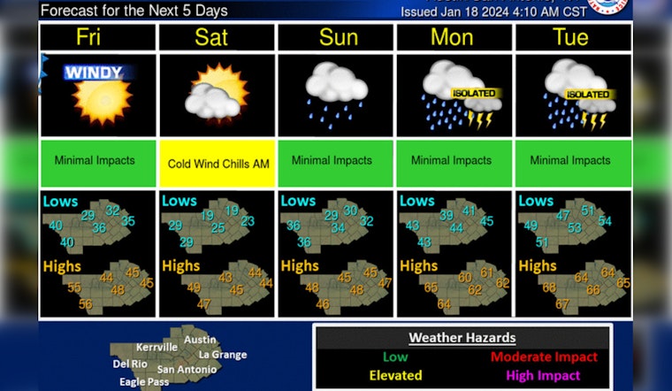
A chilly and dry start to the weekend is in store, but conditions will quickly change Sunday through mid-week next week. A series of upper level disturbances are expected to bring widespread rainfall to the area, with heavy rainfall possible at times along and east of I-35. #txwx pic.twitter.com/FZVauCU1ob
— NWS Austin/San Antonio (@NWSSanAntonio) January 18, 2024
Starting Friday, temperatures are set to plummet, with gusty north winds making morning lows in the 30s feel more like teens and 20s, and afternoon highs will struggle in the 40s, "an uncomfortably cold day but not nearly as brutal as what we had behind the Arctic cold front earlier this week," KXAN reports. The weekend continues the chilly trend with a hard freeze expected Saturday morning and highs barely climbing back to the low 40s.
Looking ahead, a series of disturbances will disrupt the calm by late Sunday, potentially bringing heavy rain to the region well into next week. "With plenty of moisture streaming in, these disturbances will send waves of scattered to widespread rain to Central Texas, some of which could be heavy at times," per KXAN's forecast.
Central Texans should brace for possible flash flooding from Sunday into Monday, the forecast indicates a risk of 1"-3" of rain, with areas east of I-35 potentially seeing higher totals. KXAN warns of the continued threat through mid-next week as rain chances persist, with a 90% likelihood on Sunday night and Monday. The weather service's outlook suggests a week of showers and possible thunderstorms from Sunday, peaking on Monday with a high near 59 degrees and gusts up to 20 mph.


