Minneapolis residents woke up to drizzle and widespread fog this morning, with meteorologists warning of hazardous conditions on the road. The National Weather Service (NWS) in Twin Cities/Chanhassen, MN, alerts that visibility could drop below 1/2 mile at times, and there's potential for a freeze as the mercury dips tonight. According to NWS forecasts, the foggy start is just the beginning, and a sizable area around Minneapolis MN is blanketed under this hazardous weather outlook.
Moving into the weekend, Minneapolis can expect a cloudy Saturday, eventually giving way, to a mostly sunny day with highs near the upper 30s. The clouds pull back further on Sunday with calm winds, signaling a partly sunny sky. However, areas of freezing fog are on the book before 11 am on Saturday, potentially challenging early risers and travelers again. Despite this consistently murky outlook, there are no severe weather alerts in place beyond the fog.
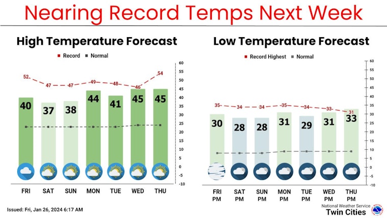
Areas of fog will continue through Saturday morning. Clouds should begin to break up Saturday afternoon with a mix of sun and clouds then expected through next week. Temperatures will remain well above normal and will near record levels for much of next week. #mnwx #wiwx pic.twitter.com/0YenyLapQF
— NWS Twin Cities (@NWSTwinCities) January 26, 2024
The upcoming week seems to ease the fog, with the weather service projecting a gradual climb in temperatures. Monday forecasts a sunny disposition with highs peaking around 44 degrees, heading into a generally warm and partly sunny stretch into Thursday.
For those navigating the fog-laden conditions, precaution is advised. The Hazardous Weather Outlook advises the Twin Cities metro, is not in immediate danger of drastic weather phenomena beyond the fog for the coming days. Residents commuting are advised to stay alert, especially during the morning hours when visibility is most compromised, for the safety of all on the Twin Cities' roads.


