Minneapolis residents can expect a partly sunny day with a high near 8 degrees, but they should bundle up as wind chill values could drop to a biting -13, according to the National Weather Service. A west-northwest wind of around 10 mph ensures that things are brisk throughout the day.
We have at least a hat-trick of days left before we see a reprieve from this arctic air mass. A system may provide some chances of light snow across Southwestern MN Thursday. #mnwx #wiwx pic.twitter.com/8tCtrehpV0
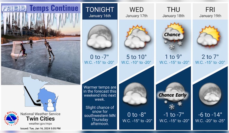
— NWS Twin Cities (@NWSTwinCities) January 16, 2024
As night falls, don't plan to shed any layers. The weather will turn mostly cloudy, with lows hovering around -1 and the northwest wind holding steady at approximately 5 mph. Thursday will bring a 20 percent chance of snow after noon, with increasing clouds and similar temperatures. Wind chill values could harshly feel as low as -10, so commuters should prepare for another frosty day.
The outlook for Thursday night isn't much warmer. Mostly cloudy skies will continue, and temperatures are predicted to dip to around -1 again. Intensifying the chill, the north-northwest wind at around 10 mph could make it feel like it's -14.
Friday's forecast doesn't promise much in the way of warmth, either. Expect mostly cloudy conditions with a peak temperature near 6, and the north-northwest wind around 10 mph once again to contribute to the rawness of the day. The night should see a bit of reprieve as skies become partly cloudy, but with a low near -7, it's a small comfort at best.
The weekend will start on a sunny note with Saturday forecasted to reach a high near 10, a west-northwest wind turning south-southwest in the afternoon offering a slow rise in the mercury. By Saturday night, however, the temperature will drop, settling around 1 while a south wind picks up, gusting as high as 25 mph.
Sunday's weather appears to be marginally better. The day will be partly sunny with a high near 20, though it will be breezy with a south wind of 15 to 20 mph, with potential gusts reaching 30 mph. Those conditions are expected to persist into the night, with the thermometer only slightly dipping to 18, keeping it mostly cloudy and breezy.
The start of the next week will see a slight shift as Monday's temperatures rise to a high near 32 with a south wind continuing at 10 to 15 mph. Monday night raises the possibility of a slight chance of rain or freezing rain, as clouds hover overhead and temperatures remain at a more moderate 25 degrees. The chance of precipitation is 20 percent, so while the likelihood is low, an umbrella should not be, out of reach. Tuesday's forecast anticipates a persisting 20 percent chance of rain amid cloudy skies, with highs pushing towards a more comfortable 35 degrees.


