Austin residents can breathe a sigh of relief as the threat of severe storms has diminished, but are not completely in the clear from scattered rainfall. According to a report by KXAN, the severe weather threat decreased overnight, though showers and thunderstorms are expected to persist in some areas. The storms could still produce brief, localized wind damage or a short-lived tornado until the early hours.
While Friday saw a complex of thunderstorms that led to Severe Thunderstorm Warnings and even a brief Tornado Warning for the Fayette/Bastrop County line, there were no confirmed reports of severe hail, wind, or tornadoes in the Austin area. "Some scattered rain redevelops overnight elsewhere, but is not expected to be severe," KXAN stated. A tornado did however touch down in Haskell County, north of Abilene, demonstrating the storm's capability.
8:05am: much of the showers and storms associated with the overnight activity has exited the local area to the east, however strong flow in the mid and upper levels of the atmosphere are helping produce some isolated showers across portions of the Hill Country. #txwx pic.twitter.com/6oZwJC8dp2
— NWS Austin/San Antonio (@NWSSanAntonio) February 3, 2024
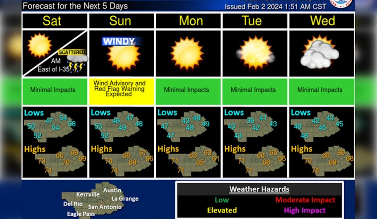
The National Weather Service has forecasted that rain is likely to exit the area by early morning Saturday, making way for sunny and breezy conditions in the afternoon. Yet, Austinites should brace for strong west-to-northwest winds on Sunday, with gusts that may reach up to 40-50 miles per hour. An advisory is in place as a dry cold front passes through the region.
According to a Hazardous Weather Outlook issued by the National Weather Service, strong winds and drier air are forecasted today across the southern Edwards Plateau and Rio Grande, with the potential of gusts up to 45 mph. The advisory is in effect for Val Verde, Edwards, and Kinney counties, and a Red Flag Warning has been announced for Val Verde County this afternoon.
The outlook for the month of February suggests potential drought relief, with an El Niño pattern expected to bring wetter-than-normal weather to the region. This comes as welcome news for an area continuing to seek relief from persistent dry conditions.


