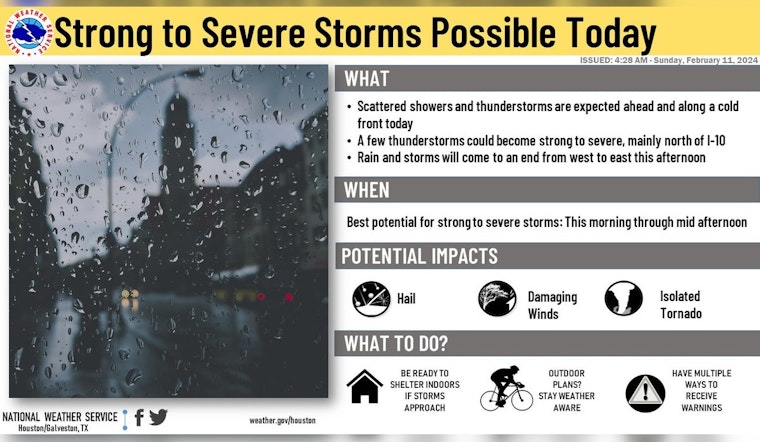
Houston is bracing for a tumultuous weather day ahead. The National Weather Service (NWS) has issued a stern warning for possible severe thunderstorms. Residents of Houston and areas north of I-10 are being urged to stay alert, as scattered showers and thunderstorms are set to roll in, with the likelihood of severe weather conditions heightening throughout the day. A Severe Thunderstorm Watch remains firmly in place as the region grapples with these developments.
As for the detailed forecast, a 40 percent chance of showers and thunderstorms, mainly before 2 pm, was reported by the National Weather Service. The temperatures could soar as high as 75 degrees, with south winds shifting westward in the afternoon. Conditions are expected to clear later today, with partly cloudy skies ushering in and a low hovering around 43 degrees. The NWS also projects that Monday will welcome sunny skies but with gusty conditions, as winds could reach up to 30 mph.
The threat of severe storms is not confined to a simple downpour or gusty winds, but extends to risks of significant wind damage and the possibility of tornadoes. According to NWS Storm Prediction Center, "Organized thunderstorm clusters, associated with wind damage and a few tornadoes will be likely across parts of the Southeast on Monday." Forecasters at the Storm Prediction Center are eyeing an upper-level low that will usher in a strong mid-level jet across the Gulf Coast states, which, combined with high surface dewpoints and temperatures, is prime for destabilization and potentially severe thunderstorms.
Residents are being cautioned to stay vigilant and to keep an eye on the skies as well as on updates from weather authorities. The storm's impact could span a sizable swath of the Southeast, with hazardous conditions expected to persist through late afternoon and early evening. Such a weather event, underscored by an NWS Houston post, calls for a heightened sense of preparedness among locals, with particular attention to those who have outdoor plans. "⚠️If you have outdoor plans today, make sure you are weather-aware & prepared," the NWS Houston post cautioned.
⚠️If you have outdoor plans today, make sure you are weather-aware & prepared. Scattered showers & storms are expected with the best chances for areas north of I-10. Some of these storms could become strong to severe. A Severe Thunderstorm Watch remains in effect. pic.twitter.com/NrrwrjEOWq
— NWS Houston (@NWSHouston) February 11, 2024


