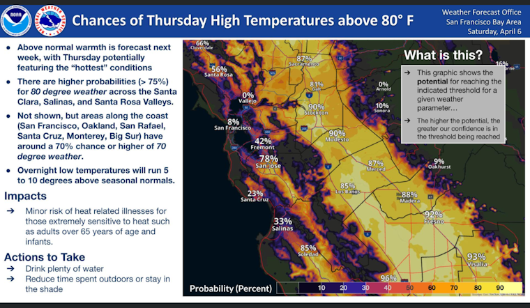
The National Weather Service (NWS) in San Francisco predicts scorching temperatures that could hit 80 degrees in parts of the Bay Area by Thursday, with the fieriest conditions expected inland in the Santa Clara, Salinas, and Santa Rosa Valleys. NWS forecasts suggest a greater than 75% chance these areas will see the mercury rise that high, with coastal spots also likely to bake with a 70% chance of topping 70 degrees. NWS officials warn that the week's warmth could spell trouble for certain people particularly sensitive to heat, such as the elderly, young children, or those without adequate hydration and cooling.
According to a statement obtained by the National Weather Service San Francisco, the dry and increasingly hot weather is also expected to persist well into the week, raising concerns of possible "heat-related impacts," particularly for those not yet accustomed to the rising temperatures. Monday through Thursday has been signaled as a period with modest "Heat Risk," due to the conditions being a sharp and potentially perilous shift from recent cooler weather. "The 80 degree temps through the middle of this week will feel warmer than 80 degrees experienced in September since it's the warmest of the season so far," the National Weather Service (NWS) in San Francisco cautioned.
In its Area Forecast Discussion, the NWS details that a weak cold front is currently passing through the region, kicking up some light showers over the waters and bringing high clouds across the skies. The weather is anticipated to clear up today with slightly below-normal temperatures and breezy conditions, particularly along the coast. It predicted there could be northwest gusts ranging from 25-30 mph.
But by midweek, temperatures are expected to shoot up, with Wednesday potentially marking the hottest day as inland valley locations edge towards the mid-80s, "10 to 15 degrees above seasonal normals for these areas," National Weather Service experts noted, pointing out the deceptive risk these early-season high temperatures may pose. However, the heat wave is anticipated to wane by next weekend, as the ridge breaks down, making way for another weather system that will likely restore temperatures back to seasonal averages.
For aviators, the NWS projects that flight conditions will remain predominantly favorable outside of strong afternoon gusts. Hints of low clouds and mist might touch down briefly in the North Bay terminals, while visibility may fluctuate at San Jose International Airport. Boaters are also being cautioned as a strengthening northwest wind will amplify Sunday afternoon, stirring up rough seas along the coast, particularly for vessels operating in the exposed waters.


