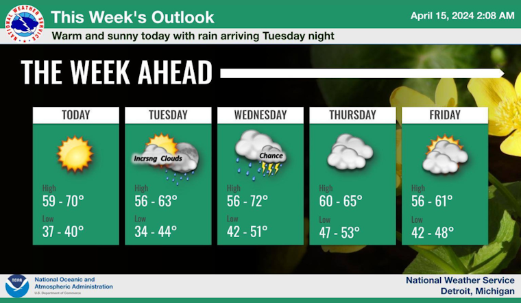
Detroit residents can expect a mixed bag of weather this week, with sunshine, likely showers, and the possibility of thunderstorms on the horizon. The National Weather Service forecasts a sunny day today with a high near 68 degrees and light winds turning westerly. The calm conditions are projected to shift tonight as the winds change direction, with an expected low around 43.
Things start to change on Tuesday, when the skies will be partly sunny and temperatures will be slightly cooler, with highs around 61 degrees alongside an east wind blowing at around 10 mph. By Tuesday night, residents should have their umbrellas at the ready, the showers are expected to start after 2 a.m., with an over 70% chance of precipitation, and the temperatures are expected to hover around 50 degrees.
According to the National Weather Service, Wednesday will be wet, with showers throughout the day and the potential for thunderstorms after 2 p.m. With southeast winds up to 15 mph, gusting as high as 23 mph, and chances of precipitation at 100%, it's a good idea to prepare for significant rainfall, which could be between a half and three-quarters of an inch.
The rest of the week seems to offer a reprieve from the heavy rains, but won't be entirely dry. Wednesday night's forecast indicates a likelihood of showers and possibly a thunderstorm before 11 p.m., then a chance of showers running into the early hours of Thursday. With the clouds sticking around, and a low around 54, Thursday's high is projected near 64 degrees, which suggests a cooler, yet still comfortable day ahead.
Looking further ahead, Detroit's weather narrative continues on a mainly cloudy note with mild temperatures. Friday's outlook calls for partly sunny skies and a high near 63, while the weekend partially clears up, heralding mostly sunny conditions by Sunday with a high near 56 degrees, according to the latest update from the weather service's detailed forecast.


