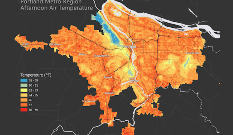
In what's being dubbed a "groundbreaking" effort, officials in Multnomah, Washington, and Clackamas counties have rolled out the results of an extensive heat mapping study that starkly highlights the disparate impact that scorching summers are having across the Portland metro area. The project, conducted on July 22, 2023, armed 125 volunteers with special gear to gauge temperature disparities neighborhood by neighborhood, uncovering critical data that could save lives as the mercury continues to rise due to climate change.
The sprawling study saw participants attach heat-measuring equipment to their vehicles, as they drove through the region collecting an impressive heap of over 269,000 temperature readings, spanning a 400-square-mile area. Despite the project’s scope, it's the first of its kind to embark on such a vast mapping endeavor, in a league with a global cohort of communities organized by NOAA in the previous summer. Brendon Haggerty of Multnomah County described the effort as "a powerful tool for protecting public health" and stressed the importance of neighborhood-level data in climate response, according to a statement obtained by Multnomah County.
Not just a data collection drive, this initiative emphasized a community-centric approach, involving locals in the study, and building a framework for the utilization of the information gathered. "Collecting the data was a collaborative process, one that continues as we learn how to best use this data together," stated Kathleen Johnson, Washington County's environmental health coordinator, indicating the county’s investment in working alongside residents to combat heat-related risks, as per Multnomah County.
With actionable insights now on hand, Clackamas County Health Officer, Dr. Sarah Present pointed out the importance of empowering those most at risk, encouraging them to "prepare and adapt." Residents in hotter zones are urged to harness the newly released data to plan for increasingly warm summers and to take proactive measures in coordination with their communities. The study converted into a free, accessible map and a detailed report, is set to guide future steps by the three counties and their partners as they brace for the climate-spurred thermal upturn.
The digitized map and subsidiary report are slated to pave the way for pre-emptive strategies and interventions aimed at cooler, more livable neighborhoods amidst the ferocity of future heatwaves. With translated summaries soon to follow, the initiative marks a significant leap toward acknowledging and addressing the clear-cut divide in the lived experiences of heat across the Portland metro area, bridging the gap between information and action.


