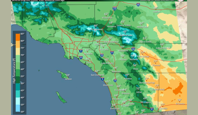
Californians can expect a range of weather conditions this week as an upper-level trough deepens, causing a cool down before temperatures climb back up midweek. According to the National Weather Service in San Diego, "Breezy onshore winds will help keep today's high temperatures several degrees cooler than seasonal average." However, residents should prepare for a reversal on Monday, as offshore lows will heat things, bringing gusty winds from the north to northeast across Southern California.
As stated by the same service, Monday's forecast suggests "Offshore low will help temperatures warm several degrees across Southern California," which could mean a significant uptick from Sunday's breezy conditions. These changes are typical of the season but can catch residents off guard who expect more consistent weather patterns. The National Weather Service's Area Forecast Discussion indicates, "There could still be some areas of 30-40 mph wind gusts mainly in the Inland Empire on Monday, with stronger winds in the typical wind-prone mountain areas."
The weather will remain active as high pressure builds after Tuesday, leading to warmer and drier conditions midweek. Specifically, "High temperatures across SoCal on both Wednesday and Thursday may top out 6-10 degrees warmer than seasonal averages," said the National Weather Service, hinting at an early taste of summer. However, coastal dwellers and mariners have a rougher start to their week, facing potential marine hazards, the agency issuing a Small Craft Advisory effective from Sunday afternoon to early Monday morning, highlighting that gusts could pick up to 30 knots in outer coastal waters.
Looking toward the weekend, forecasts become more ambiguous. Another trough may steer toward the West Coast, bringing a chance for more clouds and possible precipitation, because the "forecast becomes a bit more murky as another trough, potentially with a closed upper low, approaches the West Coast," the National Weather Service's discussion also points out the presence of diverse weather models making it tricky to nail down the specifics of late-week conditions. Despite the uncertain weekend outlook, Skywarn activation is not currently on the agenda, though spotters are encouraged to stay vigilant and report significant developments.


