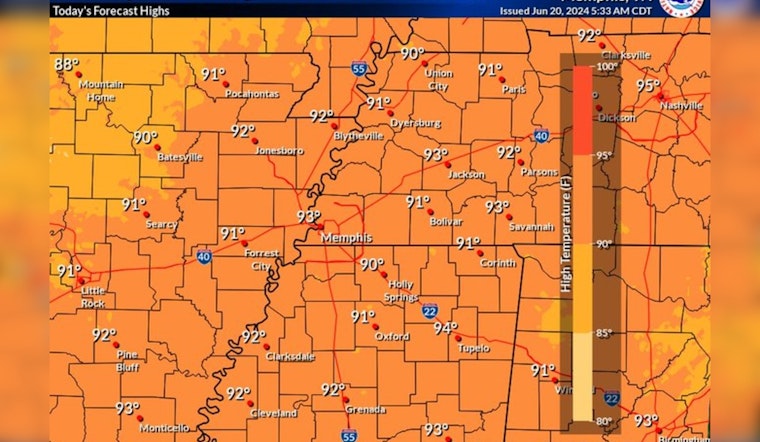
Memphis is bracing for a wave of heat in the coming days, with temperatures forecasted to rise as high as the mid-to-upper 90s, according to the National Weather Service. Residents can expect a series of partly sunny to mostly clear skies starting today, yet the climbing mercury will be the main headline. For those stepping outside this morning, the weather is partly cloudy with a calm wind, keeping today's early hours at a moderately warm 73°F, according to the National Weather Service.
Hot temperatures begin to return this afternoon. Temperatures in the middle to upper 90s expected by the upcoming weekend. Rain chances will remain minimal until next week. #tnwx #arwx #mowx #mswx #midsouthwx pic.twitter.com/1hRhYtIhgO
— NWS Memphis (@NWSMemphis) June 20, 2024
East winds, subtle in their movement, will become the norm throughout this period, barely reaching 5 mph. Such gentle breezes offer little respite from the heat that will claim the day—climaxing near 93 degrees this afternoon. The National Weather Service projects an even hotter Friday, with the high potentially cresting at a scorching 96 degrees and calm winds shifting eastwardly.
As the weekend approaches, the city will see temperatures soaring closer to the century mark. Saturday's forecast features unyielding sun with a high near 97, escalating to 98 on Sunday, challenging outdoor enthusiasts and workers alike. By nighttime, the temperature will lower to the mid-70s, giving a short-lived reprieve to those caught in the daytime swelter.
Starting Sunday night, there's a modest possibility of showers and thunderstorms with a 20 percent chance after 1 am, introducing variability into the otherwise consistent weather pattern. This uncertainty extends into the workweek, with a lingering 20 to 40 percent chance of rain and storms, primarily at night. Despite these chances, the start of the week will harness an almost unyielding sun with daytime highs hovering near 98 and Monday night settling at 77 degrees, as per the National Weather Service.


