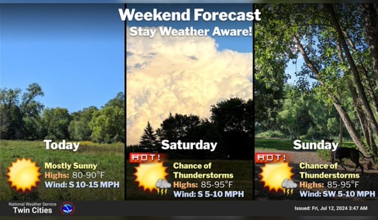
The city of Minneapolis is slated for a bout of warm and mostly sunny weather with intermittent chances of showers and thunderstorms over the next few days, according to the latest forecasts. According to the National Weather Service, today will be sunny with a high approaching 87 degrees, accompanied by a gentle south wind blowing at 5 to 10 mph.
Heat & humidity ramping up for this weekend. Potential for multiple rounds of thunderstorms Saturday through Monday. Some storms could be strong/severe, particularly during Saturday & Sunday afternoon/evening. Stay weather aware if you're heading outdoors this weekend #mnwx #wiwx pic.twitter.com/p0d3VYLyhs
— NWS Twin Cities (@NWSTwinCities) July 12, 2024
Tonight, residents should anticipate a slight change in this pattern, with a 20 percent chance of showers and thunderstorms not making their appearance until after 4 am. Skies for the most part will remain mostly clear, bowing to a low around 71, carrying the south-southeast wind from earlier, as per the National Weather Service. Going into Saturday, a similar chance of precipitation persists, ceding before the afternoon hits. The high is expected to swell to near 91 degrees, with heat indices possibly cresting at 95 under predominantly sunny skies.
For those making plans for Saturday night, they might want to pack an umbrella as there's a 30 percent chance of rain activity, which could bring showers and thunderstorms to the area. Despite this, the night will be partly cloudy with a gentle south wind shifting to a calming breeze post-midnight while temperatures drop to a low of around 73.
Continuing the trend, Sunday's weather promises to be mostly sunny yet again, despite a lurking 20 percent possibility of sporadic showers and thunderstorms. The mercury is forecasted to push upwards to a near 92 degrees, with a slight breeze coming out of the west, that's changing direction in the east-northeast by morning, as detailed by the National Weather Service. Clear skies are expected come Sunday night with the low settling near 70, as the west wind tapers to a calm state as dusk approaches.
Looking at the start of the workweek, Monday holds a 30 percent chance of precipitation with showers and thunderstorms anticipated to develop after 1 pm. Still, most of the day will see mostly sunny conditions with high temperatures hovering around 87 degrees, and a typical west wind moving at 5 to 10 mph, as reported by the National Weather Service. The evening is expected to be mostly clear, as temperatures dip to a lower 64 degrees, the northwest wind maintaining a steady draft.
As the week progresses, a trend of sunny days continues, the National Weather Service highlights, with a high near 78 degrees forecasted for Tuesday. This pattern of clear skies and comfortable highs in the late 70s is predicted to extend at least through Thursday.


