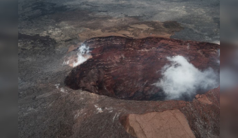
The Kīlauea volcano on Hawaii's Big Island is undergoing intense seismic activity, with nearly 1,000 earthquakes over the last three days, shaking the region with alarming regularity. According to Big Island Now, 250 of these tremors have been powerful enough to exceed a magnitude of 2, with the largest recorded at a magnitude of 3.6. The earthquakes are concentrated between 0.6 and 1.8 miles beneath the surface, triggering concerns among researchers and residents alike.
The Hawaiian Volcano Observatory has observed a significant seismic swarm and ground inflation under the East Rift Zone, indicating the movement of magma through the zone's dike system, causing tremors and disturbing the ground above. These seismic fluctuations, detailed by Volcano Discovery, are focused between Pauahi Crater and Maunaulu along Chain of Craters Road in Hawaiʻi Volcanoes National Park. Seismic activity peaked with a series of events, normally spanning 2–3 hours in duration, suggesting an ongoing and unrestful magma intrusion.
An eruption is not immediately expected, but the unpredictability of the volcano's behavior has left authorities on alert. "An eruption is not currently imminent, but conditions could change rapidly," noted the Hawaiian Volcano Observatory, expressing the inherent challenge of forecasting Kīlauea's next move. In the past, eruptions on the upper East Rift Zone have sprung up with little more than an hour's notice, highlighting the precarious nature of the situation, as reported by Big Island Now.
As a measure against a potential eruption, Hawai‘i Volcanoes National Park has executed temporary closures, and members of the public are advised to stay informed on park updates. The Hawaiian Volcano Observatory has installed additional monitoring cameras, including the KOcam at Maunaulu and the K2cam at Uēkahuna bluff, to keep a close and constant watch over the area's activity.
The recent spikes in seismic activity and the corresponding ground deformation in Kīlauea's summit region indicate that the magma may be filling a shallow, vertical fissure-shaped intrusion, also known as a dike, under the East Rift Zone, which have deflated as magma advances. The threat level of Kīlauea was briefly raised from advisory/yellow to watch/orange due to these developments, before pulsing back to usual levels of unrest. The future movements of this magma and the potentiality of an eruption, however, remain under the vigilant eye of Hawaiian Volcano Observatory researchers, as the Earth beneath Kīlauea whispers of turmoil not yet quelled.


