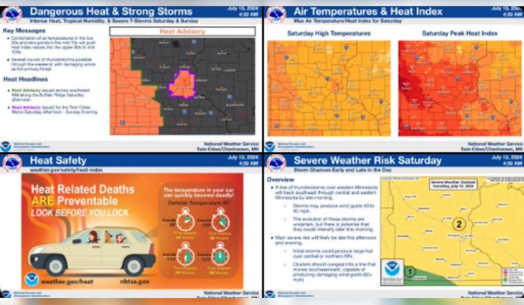
Residents across the Twin Cities are bracing for a steamy weekend, with the National Weather Service (NWS) in Twin Cities/Chanhassen, MN issuing multiple advisements on weather conditions that could put locals at risk. According to the National Weather Service, a Heat Advisory remains in effect from 2 PM Saturday until 8 PM Sunday for several counties, including Hennepin, Anoka, Ramsey, Washington, Carver, Scott, and Dakota. With heat index values predicted to notch up to 98, the heat, coupled with high humidity, may result in heat illnesses.
Hot & humid weather for the weekend. Temperatures will be in the upper 80s to mid 90s Saturday and Sunday with heat indices in the mid 90s to low 100s. Potential for several rounds of strong to severe thunderstorms this weekend. Stay alert if you have outdoor plans! #mnwx #wiwx pic.twitter.com/WpOrRRMzrl
— NWS Twin Cities (@NWSTwinCities) July 13, 2024
Moreover, the region isn't just facing sweltering heat. There's a chance for showers and thunderstorms throughout the weekend. As per the NWS forecast, there is a 40 percent chance of precipitation today with a slight chance of showers and thunderstorms after 5 pm. Evenings may bring some respite with the possibility of partly cloudy skies and lows around 71. Saturday night, specifically, anticipates a 50 percent chance of showers and thunderstorms, mainly between 7 pm and midnight.
In addition to high temperatures and storm risks, the NWS cautioned about "Potential for two rounds of thunderstorms today. Morning storms will move into W MN by sunrise and through central MN by late morning." The primary concern with these storms is the damaging wind gusts that they might bring. Later in the day, a second wave of storms could again pose a threat, with the possibility of large hail if they occur, as indicated by the Hazardous Weather Outlook.
The weather is impacting not just the atmosphere but also the local waterways. The NWS has extended a Flood Warning for the Minnesota River at Savage. The waterway's risen past its flood stage, impacting nearby parks such as Fort Snelling State Park. While river levels continue to drop, upcoming precipitation may slow the recession. "The river is expected to fall below flood stage Monday evening and continue falling to 699.1 feet Friday, July 19," details the NWS flood statement, suggesting that locals still need to remain vigilant around waterways.


