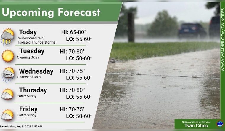
Minneapolis residents are gearing up for a wet and stormy start to the week, with the National Weather Service in Twin Cities issuing a forecast that includes showers and the possibility of a thunderstorm after 10 a.m. today. The high is expected to be near 70 degrees, accompanied by an east northeast wind at 5 to 10 mph.
Today will be cool rainy with moderate to heavy rain possible. Storms possible across southern MN with some strong to severe. Next rain chance on Wednesday with cooler weather continuing through the week as highs generally stay in the 70s. #mnwx #wiwx pic.twitter.com/F8vMwNSqyS
— NWS Twin Cities (@NWSTwinCities) August 5, 2024
According to the National Weather Service, there's an 80 percent chance of precipitation today, with new rainfall amounts stacking up between three quarters and one inch. As tonight rolls in, showers and thunderstorms are mainly anticipated before 1 a.m., some could produce heavy rainfall, with new rainfall amounts between 1 and 2 inches possible — signaling a soggy evening ahead.
Residents should also be aware of the potential for hazardous weather. The Hazardous Weather Outlook alerts that scattered thunderstorms, capable of gusty winds and hail, are expected to develop later today, particularly in areas near I-94.
Some locations near the aforementioned interstate may see significant rainfall, "with potential for locally 3 to 4 inches," as stated by the National Weather Service. The forecast for the following days offers a respite from the tumult, with sunny skies and mild temperatures through the week. No hazardous weather is expected from Tuesday through Sunday, offering a chance for Minneapolis citizens to dry out and enjoy some clearer skies.


