Residents in Minneapolis and surrounding areas can expect a mix of mostly cloudy skies and some sunshine over the next week, with a possibility of showers and thunderstorms punctuating the forecast. According to the National Weather Service, today's temperatures are expected to hover near a comfortable 78 degrees, accompanied by a south breeze between 10 to 15 mph.
Two rounds of scattered showers and storms are possible today and tonight, especially across central and western MN. Weather trends drier and warmer this weekend with Sunday looking quite hot and humid. pic.twitter.com/gIewFNOEYT
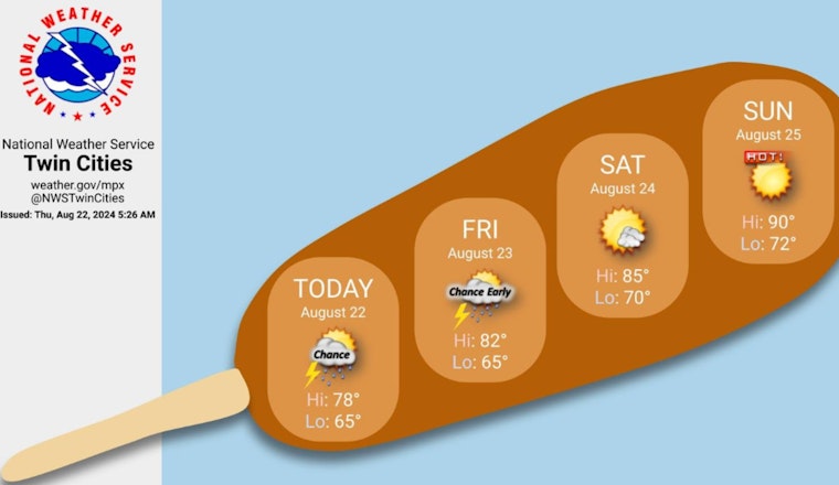
— NWS Twin Cities (@NWSTwinCities) August 22, 2024
However, tonight offers a different spectacle, with a 30 percent chance of showers and thunderstorms expected mainly between 3 am and 5 am, as detailed by the National Weather Service. The winds should persist from the south around 10 mph, and, temperatures will likely dip to a low of around 65 degrees. Friday's forecast reveals a declining chance of showers as the day begins, followed by a partly sunny sky and peak temperatures around 81 degrees.
The weekend will bring warmer conditions to the region. The National Weather Service details that Saturday should be mostly sunny with a high near 85, while Sunday will be even hotter with expected highs nearing the 90-degree mark under sunny skies.
According to a hazardous weather outlook issued by the National Weather Service, the region is not only facing a potential for brief severe weather today but also a sweltering Sunday ahead with heat indices nearing 100 degrees. "Hot and humid conditions are expected Sunday," the report notes, signaling an onset of what might be a challenging day for outdoor plans and activities.
The outlook for the early parts of next week remains consistently sunny with high temperatures in the mid-80s. Evening conditions across the specified time frame should be mostly clear with lows in the mid-60s to low 70s.


