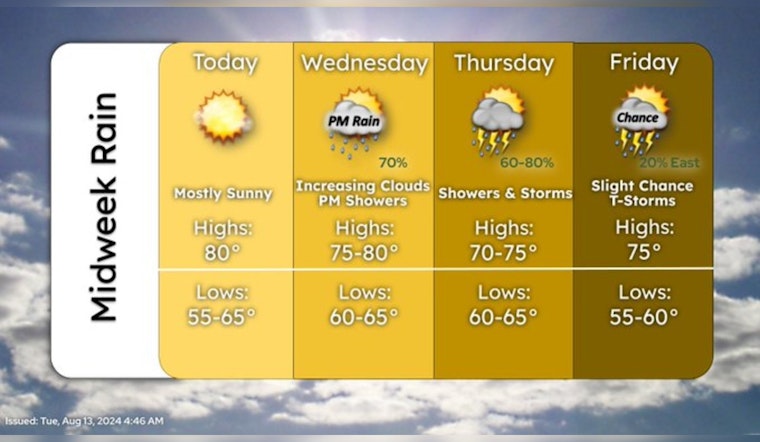
Residents in Minneapolis should enjoy the sunshine while it lasts today, as the weather is expected to take a turn with chances of showers and thunderstorms disrupting the calm of the following days. According to the National Weather Service, today's conditions will be sunny with a high near 82 degrees. Light winds from the south-southeast will be picking up slightly in the afternoon.
One more day of pleasant weather before showers return Wednesday afternoon through Thursday. Rain will start earlier (Wed AM) in western Minnesota. Lingering rain is possible on Friday, but it should be light. #MNwx #WIwx pic.twitter.com/5yhMRkPCms
— NWS Twin Cities (@NWSTwinCities) August 13, 2024
As nighttime falls, skies are anticipated to remain mostly clear as the temperature dips to around 64 degrees. However, the serene weather is not here to stay, with Wednesday bringing a 30% chance of showers between 1 pm, and 4 pm, followed by potential showers and thunderstorms after 4 pm, as per the National Weather Service. Winds from the southeast might make for a breezy day with gusts reaching up to 15 mph. In light of this, the Weather Service urges us to stay vigilant and be prepared for sudden weather shifts.
Moving on to Wednesday night, the likelihood of precipitation jumps to 90%, with showers and possible thunderstorms forecasted, possibly leading to new rainfall amounts between a half and three-quarters of an inch. The chance of wet weather continues through to Thursday, with showers and possibly a thunderstorm predicted after 1 pm amidst mostly cloudy skies. Temperatures are expected to cool slightly to a high near 74 degrees, while winds shift from the east-southeast to the north-northwest in the afternoon.
The rest of the week maintains this unsettled pattern, with a 30% chance of showers again on Friday, particularly after 1 pm, as detailed by the National Weather Service. Despite the potential for more rain, the high is expected to be a comfortable 75 degrees under partly sunny skies, and winds from the northwest at 5 to 10 mph. In the evenings, conditions slightly improve – mostly cloudy on Friday night with a low around 62 and a gentle northwest breeze. Saturday offers a small respite with just a 20% chance of showers after 1 pm, under mostly sunny skies and a high near 78 degrees.
Outlook for Sunday into early next week shows promise for those yearning for clearer skies, with a sunny Sunday and a high around 80, while Monday is looking mostly sunny with highs in the upper 70s. The National Weather Service anticipates north-northwest winds to stay constant at 5 to 10 mph.


