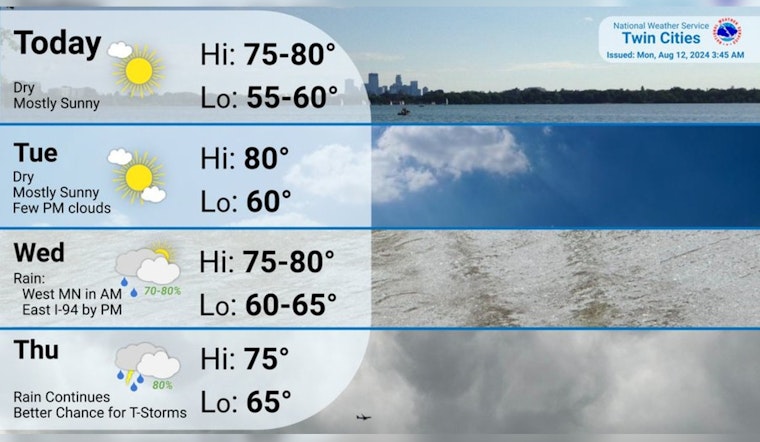
Residents of Minneapolis can anticipate a series of sunny days according to the latest forecast, with temperatures favoring a comfortable range in the low 80s. The National Weather Service reports a sunny spectacle for today, with highs teetering around 80 degrees and the calm wind adding to the tranquil outdoor ambiance. Those with evening plans should be mindful of patchy fog settling in after 5 am, though the night's sky should remain mostly clear with a low near 60.
Quiet and sunny weather through Tuesday. .🌞
— NWS Twin Cities (@NWSTwinCities) August 12, 2024
Shower chances arrive Wednesday into Thursday, with a few t-storms possible on Thursday. We look to stay comfortably warm with temperatures in the mid to upper 70s through this week into the weekend.#MNwx #WIwx pic.twitter.com/vcRFi2XSOI
As the workweek progresses, Tuesday promises a repetition of sunshine, wiping away the early fog before 7 am. The high is expected to notch up ever so slightly to about 81 degrees, as per the National Weather Service. Calm winds taking a southern direction at approximately 5 mph are on the afternoon agenda,, offering respite to any residual humidity. Nightfall ushers in only partly cloudy skies, while temperatures dip to a low around 63 degrees. A gentle southeast breeze complements the evening's ambiance.
Midweek weather shifts, beckoning showers post 1 pm according to the service's foreboding predictions. Wednesday's skies will partially cloak the sun, and while the high remains a warm 80 degrees, a precautionary note of a 30 percent chance of rain has been sounded. A southeastern wind is expected to pick up speed, ushering in moisture with 5 to 10 mph gusts.
Thursday intensifies the likelihood of rainfall, there's a steady 60 percent chance of precipitation, bringing showers and possible thunderstorms after 1 pm, as detailed by the National Weather Service. Heavier clouds gather to reflect a stormy tableau, with rainfall estimates accumulating between a half and three-quarters of an inch, an unwelcome guest—though some gardeners might disagree. The anticipated high of 75elsius may bring some solace, alongside a southeast wind that holds steady between 5 to 10 mph.
As the workweek wanes, Friday and the weekend lend themselves to a lighter prediction. Friday's forecast entails a mere 30 percent chance for afternoon showers and thunderstorms, with the skies clearing to partly sunny. This eases into a 20 percent chance of showers after 1 am and creates a hopeful outlook for the weekend. Saturday's forecast indicates a largely sunny day, continuing with a minor chance of showers and a high near 78. By Sunday, the city should return to a mostly sunny climate with highs also hovering near 78, all with the helping hand of a north wind blowing at a mild 5 to 10 mph.


