The National Weather Service in Knoxville has forecasted a slight chance of showers, transitioning into a more significant chance of showers and thunderstorms across the region this afternoon. According to the latest weather update, most areas will experience mostly sunny skies, with highs reaching toward a warm 87 degrees. Winds are expected to be light, coming from the east at 5 to 10 mph.
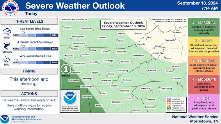
Remnants from Francine may pose an isolated threat for severe weather this afternoon and evening for our extreme southern plateau and TN valley. Small supercells are possible with the chance of a tornado. pic.twitter.com/O6bTuyiK9T
— NWS Morristown (@NWSMorristown) September 13, 2024
As the day transitions into the evening, there's a 30 percent chance of lingering showers and thunderstorms, mainly before 7 pm. "Mostly cloudy, with a low around 68," is the anticipated nighttime outlook, with a continuation of the northeast wind, as detailed by the National Weather Service. Similar patterns will carry into the weekend, with the added note of gusty winds through Sunday as the remnants of what was Tropical Storm Francine pass through the area.
Looking further ahead, Saturday appears to hold a 40 percent chance of precipitation, with opportunities for rainfall lasting through the evening. The forecast, obtained from the National Weather Service's website, suggests mixed weather conditions that include both partly sunny skies and periods of potential showers. The high temperatures are expected to hover comfortably in the mid-80s.
A hazardous weather outlook has also been issued for the region. The alert, as advised by the National Weather Service's Morristown TN station, emphasizes the far east Tennessee mountains and foothills where intense winds have warranted a Wind Advisory. “East to southeast winds of 20 to 30 mph with gusts to 50 mph will be possible in the foothills and the higher elevations through mid morning,” the advisory states.
Although spotters are not requested at this hour, the situation will continue to be monitored. Residents and visitors in the affected areas are advised to stay alert to changing weather conditions and consult the National Weather Service for the latest updates and advisories.


