The Twin Cities area is facing a mix of weather conditions in the coming days, according to the National Weather Service's latest reports. For Minneapolis, MN, the forecast is calling for mostly sunny skies today, September 17, with a high near 88 degrees, accompanied by a south wind moving at 10 to 15 mph, with gusts as high as 25 mph. As the sun sets, partly cloudy skies will prevail, dipping to a low of around 70 degrees, with a south-southeast wind of around 10 mph, according to the National Weather Service.
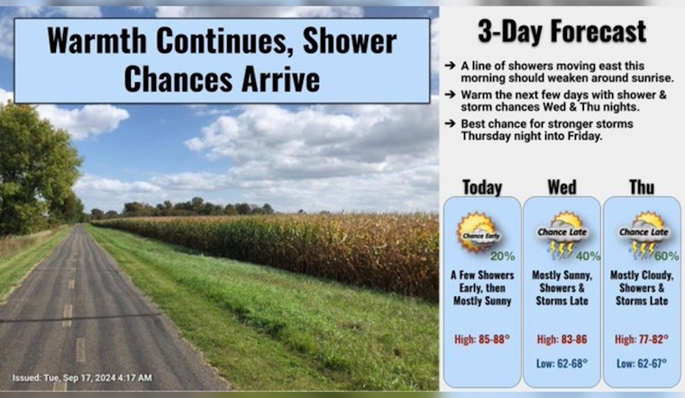
A line of showers and weak storms in western MN this morning will weaken as they move east, with mostly clear skies by the afternoon. Warm again today with highs in the mid to upper 80s.
— NWS Twin Cities (@NWSTwinCities) September 17, 2024
Shower and Storm chances arrive both Wed/Thu nights. #mnwx #wiwx pic.twitter.com/qd3sBRgeor
The following days are expected to maintain mostly sunny conditions with highs in the mid-80s. However, the weather starts to turn on Wednesday night with a 40 percent chance of showers and thunderstorms, particularly after 1 am, as detailed by the National Weather Service. This is to continue into Thursday, with showers likely and possibly a thunderstorm before 1 pm. The chance of precipitation for Thursday is gauged at 60 percent, potentially bringing between a quarter and half an inch of new rainfall.
Moreover, the recent Hazardous Weather Outlook issued by the National Weather Service at Twin Cities/Chanhassen underscores the potential for severe weather. It indicates that "Thunderstorm chances, some severe, will continue Wednesday into this weekend" for central and southern Minnesota, and west central Wisconsin. Notably, spotters should not need to activate just yet, as the SKYWARN spotter activation is not anticipated for today and tonight.


