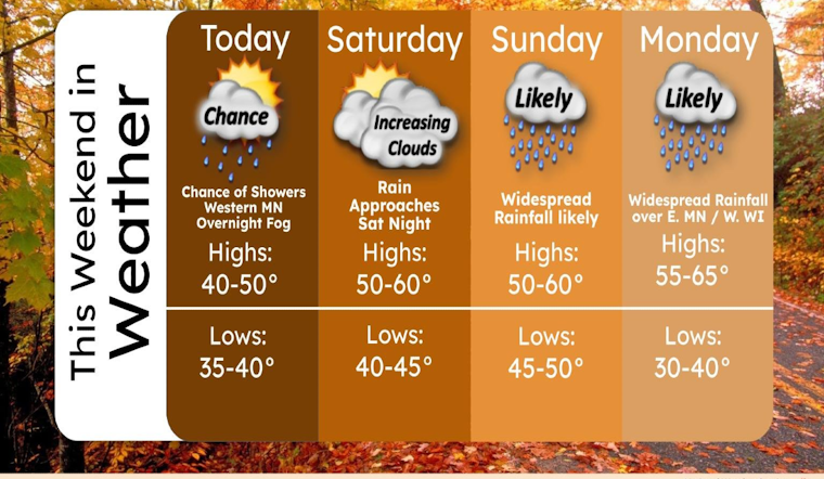
Minneapolis residents can expect a mix of fog, increasing clouds, and a calm wind today, with temperatures reaching a high near 46 degrees, according to the National Weather Service. The morning may see some patchy freezing fog before 9:00 a.m., giving way to sunnier skies in the afternoon as the wind shifts south southeast at around 5 mph.
Tonight's weather is leaning towards the cloudy side, with lows hovering around 40 degrees, and a continuation of that south southeast breeze pressing gently at 5 to 10 mph. The upcoming days, however, promise more dynamic weather patterns. Saturday brings mostly sunny conditions and a warmer high near 56 degrees with a placid south southeast wind.
The serene start to the weekend is but a precursor to what is forecasted for Saturday night and Sunday. Residents should prepare for rain, primarily after 1 a.m. on Saturday night, as there's a 90% chance of rain with the temperature dropping to about 46 degrees. Rainfall is expected to continue through Sunday, intensified by southeast winds gaining momentum at 10 to 15 mph.
As the week commences, the weather refuses to relent, with predictions of rain and possible thunderstorms on Sunday night. Temperatures will take an upward turn, rising to around 62 degrees by early Monday. The likelihood of rain stretching into Monday is high, the chance of precipitation stands at 100%, with thunderstorms possibly contributing to increased rainfall amounts.
Looking toward Tuesday and Wednesday, the National Weather Service forecasts a 40 percent chance of rain before early afternoon, giving way to mostly sunny skies with highs in the low 50s. The outlook for Wednesday night through Thursday suggests partly cloudy skies with lows in the mid-30s and mostly sunny days with highs staying consistent in the upper 40s.
For the most current weather updates and forecasts for Minneapolis, visit National Weather Service.


