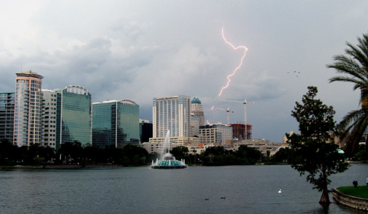
The National Weather Service in Melbourne has a clear message for Orlando's sailors today: keep your boats docked. Conditions are far from ideal, with southeast winds stirring up seas to a choppy six feet offshore, and the weather forecast isn't looking any kinder for those hoping to catch a break on the water or looking for a cozy beach day. The Service is forecasting an increase in showers and potential lightning storms, with a peak in action expected this afternoon and into the evening; they're even giving a heads up for a few severe storms that may pack strong wind gusts, hail, and quite the deluge.
Those planning outdoor activities around Orlando might want to take heed and look out for the sky. Those fluffy clouds might just unfurl into a somber grey before drenching you in their payload, the conversation with spirits of air not granting any respite today or tomorrow as the city braces for a surge in rainfall and storms. With such an embroilment of the elements, it's likely to see the unsettling dance of nature play across the skies and streets, and it's not just your regular flurry. We're talking potentially harsh wind gusts reaching 60 mph, an unwelcome hail cameo, and the kind of rain that doesn't just tap on your window. Still, pounds on it, asking for immediate attention, "Poor boating conditions continue today for Southeast winds and choppy seas," warns the official word from the National Weather Service.
However, as we leap into April, Orlando expects a warming trend. Forecasters say that peak heat indices might tap out at the lower 90s, particularly inland from the coast, for those eagerly awaiting the sun's embrace. There seems to be light, quite literally, at the end of this stormy tunnel. But before we get there tomorrow, while there is a slight reprieve with the deepest moisture pushing eastward, still expect some isolated to scattered stormy tantrums courtesy of a stubborn sea breeze and sun that insists on heating the surface just enough to stir trouble in paradise—yes, that typical Florida chaos.
The aviation outlook isn't exactly friendly either—not that it's expected to be when one pictures a sky bruised by thunderous ambitions. Pilots and travelers can anticipate disruptions with numerous showers and scattered storms predicted to develop on Sunday. The higher chance of this sky tempest will be mid-afternoon through the early evening, thanks to an alchemic blend of peak sunlight warmth, boundary clashes, and a meddling disturbance traipsing along aloft for those traveling by air. Expect possible tempo IFR/MVFR conditions when faced with these aerial spats. VFR conditions outside of convection through the TAF period, the forecast breezes in with a hint of optimism, yet temporary restrictions for thunderstorms have been penned in around 19-23Z across inland terminals where boundary collisions are favored, caution extends toward the coastal KTIX, KDAB, and MLB areas later on where return fire toward the coast is likely.


