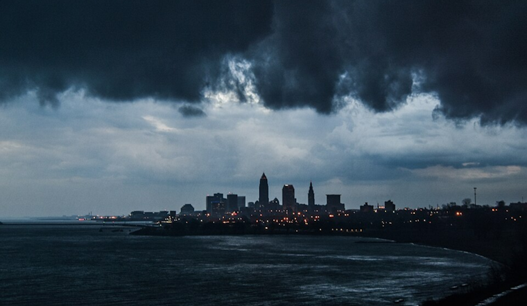
Cleveland residents should brace themselves for a medley of severe weather conditions, as a low pressure system is set to sweep through the Great Lakes region, bringing with it thunderstorms, gusty winds, and heavy rainfall. According to the National Weather Service (NWS) in Cleveland, the storm system, which originated from the Central Plains, is expected to escalate today, elevating the flood risk across the Ohio Valley into the coming weekend.
The forecast is decidedly grim. The NWS has warned that there will be "two distinct rounds of precipitation today and overnight tonight." The initial wave is predicted to include thunderstorms capable of producing strong winds and hail. Those in Northwest Ohio might see the onset of severe weather as early as this morning with the intensity and coverage expected to amplify by the late afternoon. Despite this, the main event appears to be slated for this evening, as conditions are primed to deteriorate rapidly and hazardous storms are predicted to to converge upon the area quickly.
In anticipation of the tumultuous weather, a Flood Watch has been put into effect, primarily in regions lying west of Interstate 77, from this evening through Sunday morning. Rainfall spanning from 1 to 2 inches is in the cards for most locales, but NWS also notes that the "highest flood risk will mainly occur in urban areas where thunderstorms persist." Alongside the flood concerns, residents ought to prepare for strong wind gusts, particularly in Erie County, PA, where a Wind Advisory has been placed, indicating the potential for gusts reaching the 50 MPH mark.
Ahead of this meteorological maelstrom, temperatures will see a rise, touching "the upper 60s to lower 70s" as the warm front conquers the region. However, the warmth is forecast to be short-lived; a stark drop is expected with the arrival of the cold front on Thursday. As the low-pressure inches closer, the promise of continuing inclement weather looms large. The NWS projects a likelihood of "a multiday heavy rainfall and flooding event" that could overshadow the imminent severe thunderstorm threat.
For those with their eyes to the skies, the NWS also cautions aviators of the likelihood of non-VFR conditions and advises mariners of rough conditions on Lake Erie, with intermittent Small Craft Advisories in effect. Whether on land, air, or sea, it seems that nature is all but guaranteed to be tumultuous, leaving Ohioans in the path of a storm system that will unrelentingly test their mettle.


.jpg)