The Texas Department of Transportation (TxDOT) recently took on a task beneath the surface, conducting a detailed 3D survey of the Inner Space Cavern near Georgetown, a stark deviation from their typical above-ground survey work. This subterranean venture aimed to gather precise coordinates for the cavern, which will inform future transportation projects along I-35. Gina Loftis-Franklin, a land surveyor with TxDOT's Austin District and the project lead, described the endeavor as "kind of a once-in-a-lifetime survey for us," according to TxDOT. The goal was to document the cavern's exact location to ensure its protection in the wake of upcoming construction.
Working underground for long stretches, the survey team, composed of surveyors, environmentalists, engineers, and technology specialists, coordinated their efforts across multiple TxDOT departments. Running for three days per week onsite, the team conducted their work in the cavern for a total of 18 days over four months. This allowed public access tours to continue uninterrupted at the cave, which was accidentally discovered by TxDOT itself back in 1963 during a bridge construction project.
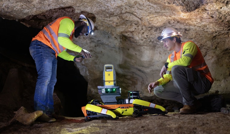
Despite the winter conditions above ground, the team members found warmth in the cave's constant 72-degree temperature and high humidity, which, however, imposed a need for the survey instruments to first acclimatize. Once recalibrated, the equipment was instrumental in scanning the known coordinates of the cave and developing a mapping system. TxDOT also deployed a LiDAR-equipped dog-shaped robot named Dot to access parts of the cavern challenging for humans to reach.
"This required months of work from a land surveyor, a surveyor-in-training and a survey intern," mentioned James Johnson, TxDOT's Transportation Programs Support director, regarding the project's complexity. The hands-on experience was particularly valuable for the junior staff members, who learned to navigate a demanding worksite far removed from the simplicity of standard land surveying.
The data collated and constructed by the team, with assistance from IT specialists, culminates in a digital twin of the Inner Space Cavern, detailing its passages, ceiling heights, and its precise coordinates beneath the surface. Ronny Lackey, TxDOT's Surveying Section Director, highlighted the meticulous work involved in developing accurate data in the absence of global positioning systems, praising Loftis-Franklin's mentorship for equipping their employees with the skills needed for such projects. Once TxDOT finalizes the data extraction and mapping, the resulting 3D model will ensure the Inner Space Cavern's preservation for future generations.


