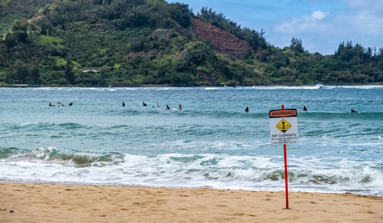
The National Weather Service in Jacksonville, FL, has issued multiple advisories for the coming days as the region braces for varied weather hazards along the Southeast Georgia and Northeast Florida beaches. According to NWS reports, a High Rip Current Risk is now in effect through Friday evening, accompanied by a High Surf Advisory that remains active until 2 AM EDT Friday. Beachgoers can also expect minor coastal flooding around the evening high tide today as a Coastal Flood Advisory takes effect from 5 PM to 11 PM EDT.
Specifically, the Rip Current Statement by the NWS cautions, "For the High Rip Current Risk, dangerous rip currents" are to be anticipated. The High Surf Advisory warns of "large breaking waves of 5 to 9 feet, as high as 11 feet." These conditions pose risks of "flooding of lots, parks, and roads with only isolated road closures expected." Additionally, the tricky riptides could make swimming perilous, and there is a potential for localized beach erosion. Residents and tourists alike are urged to take heed of the advisories, staying informed on the latest updates.
For those considering braving the waves, the NWS strongly advises swimming near a lifeguard and urges inexperienced swimmers to remain out of the water altogether during these conditions. The Rip Current Statement underscores, "If caught in a rip current, relax and float. Don`t swim against the current." The NWS suggests that if one can manage, to swim following the shoreline, and if unable to escape the current's pull, to face the shore and signal for help.
On the weather front, Jacksonville can expect a humid mix of sunny spells and thunderstorms over the next several days. Today carries a 30 percent chance of showers in the afternoon, with temperatures reaching a high near 92 degrees Fahrenheit. Thursday's forecast is upping the ante with a hotter outlook, including a 50 percent chance of afternoon thunderstorms as heat index values soar as high as 102. Taking a peek at the weekend, a significantly elevated chance of precipitation is coming Saturday, standing at 90 percent for showers and thunderstorms after 8 AM.
Residents should prepare for an uptick in shower and thunderstorm activity, especially on Friday and through the weekend, when chances of precipitation linger around the 80 to 90 percent mark. The NWS advises people to follow all precautions and preparedness actions to mitigate the risks posed by the turbulent weather and to be prepared for potentially sudden changes in conditions.


