Prescribed burns are set to carefully manage potential wildfire risks in the Apache-Sitgreaves National Forests, as the U.S. Forest Service prepares to use controlled fire as a tool to reduce the buildup of hazardous fuels. The operation is scheduled to start on Wednesday with plans to continue through November 14, depending on weather conditions. These burns aim to protect not just the local communities and infrastructure, but also the precious natural resources that reside within the forests' boundaries.
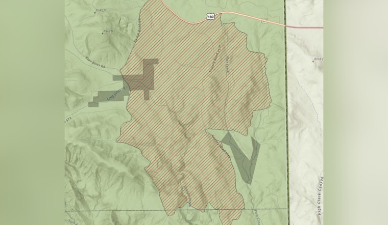
The targeted area for this deliberate incendiary work is the Pace Rx unit, encompassing some 2,062 acres situated approximately 4 miles east of Alpine, AZ, south of Hwy 180, as cited by the Arizona Emergency Information Network official announcement. To concurrently manage waste, the Alpine green waste pit will also undergo burning and will be closed to the public until the operations are complete. For public safety, nearby areas may see temporary closures, with officials putting up warning signs along roads near all prescribed fire areas before and during the burn events.
Given the proximity of the prescribed fire to populated areas, there are expected smoke impacts to Hwy 180, Alpine, and private properties directly adjacent to the Pace Rx unit. This might lead to reduced visibility, prompting drivers to slow down and activate headlights when encountering smoke. Those concerned about air quality can find more detailed information by visiting AirNow online or downloading the app for real-time updates.
Plans for these burns are not set in stone; the Forest Service has committed itself to carefully evaluating weather conditions in the hours before a controlled ignition is to be commenced. Should the weather prove unfavorable, the prescribed fire activities scheduled may find themselves canceled. Those interested in staying abreast with the latest updates can do so through the forest's website, social media channels, and InciWeb, the interagency incident information system.


