Oʻahu homeowners and renters are staring down a new kind of flood risk, and it has nothing to do with the weather. Federal flood maps have moved toward final approval, and dozens of stream-adjacent properties have been bumped into higher-risk flood zones for the first time. FEMA’s move starts a six-month countdown to updated rules that could ripple through mortgages, building permits and insurance bills. City officials are urging residents to use the window now to look up their properties and talk to lenders or insurers before the new requirements kick in, as reporetd by the City and County of Honolulu.
What the letter means
On Wednesday, FEMA issued a Letter of Final Determination that launches a six-month compliance period and sets the updated Flood Insurance Rate Maps to become effective on June 10, 2026, according to the City and County of Honolulu. The city says the finalized maps reflect years of stream studies and will require properties that fall inside Special Flood Hazard Areas to comply with the Revised Ordinances of Honolulu Chapter 21A.
Insurance and lender rules
For properties newly mapped into Special Flood Hazard Areas, the change may trigger lender-required flood insurance if the mortgage is federally backed. If required coverage is not in place within 45 days of the effective date, lenders can step in and force-place a policy. Resilient Oʻahu is urging residents to use the compliance period to talk with insurance providers, confirm whether flood coverage will be mandatory and ask about potential pre-FIRM or newly mapped discounts.
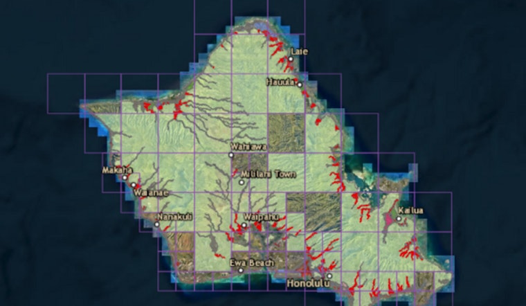
How the maps were updated
The updated FIRMs follow a multi-year FEMA study of Oʻahu streams. FEMA released preliminary maps last year, then opened a 90-day public appeal and comment window from March 13 to June 10, 2025, during which property owners could submit technical data to challenge their designations, according to FEMA. FEMA and city staff reviewed those appeals and resolved any changes before issuing the final determination.
Where and when to get help
FEMA, the state Department of Land and Natural Resources and the City plan to walk residents through the changes at a series of outreach events: a virtual open house on January 15, 2026, followed by two in-person sessions on January 21 at Kāneʻohe Community & Senior Center (45-613 Pūʻōhala St.) and the ʻAiea Public Library (99-143 Moanalua Rd.). The sessions are aimed especially at homeowners who are newly mapped into Special Flood Hazard Areas but are open to anyone who wants more information, according to the City and County of Honolulu. Registration details and background materials are available on the City’s Get Flood Ready portal.
Where to look up your property
Final FIRMs and downloadable map products are available from the FEMA Flood Map Service Center, and the City’s Get Flood Ready site offers a searchable viewer along with information on discounts and mitigation steps. Plug your address into the map portal to see whether your property falls inside a Special Flood Hazard Area, then write down the specific zone designation so you can review options with an insurance agent.
What homeowners should do now
Start by checking your address on the updated map and noting your flood zone. If you find yourself newly mapped, call your mortgage lender and your insurance agent to ask when any new requirements would start and how much premiums might change. If you believe your property was misclassified, FEMA allows technical appeals and later processes known as Letters of Map Amendment or Map Revision; see guidance from Resilient Oʻahu for next steps and links to FEMA resources. For detailed, property-specific or financial questions, plan to attend one of the January outreach sessions so you can talk directly with FEMA, DLNR and city staff before the new maps officially take effect.


