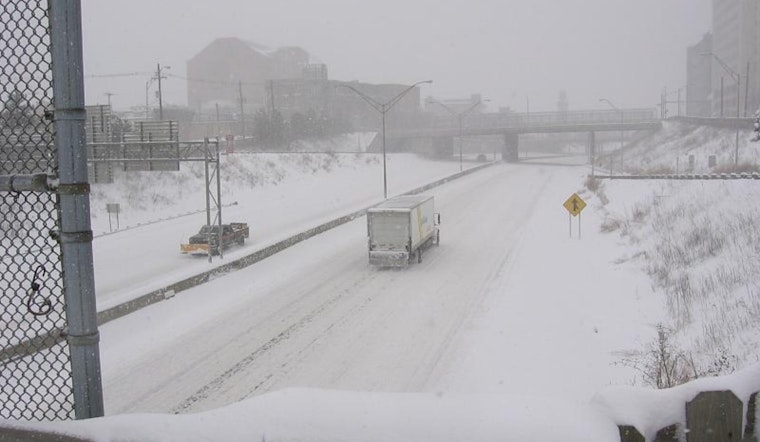
Residents across the Wilmington area are buckling down as the National Weather Service has issued a stark warning of a significant winter storm poised to blanket the region with heavy snowfall through the weekend and into Monday. The NWS in Wilmington, Ohio, alerted that the storm is expected to "bring heavy accumulations of snowfall later today through Sunday, with impacts to travel expected to continue through Monday," emphasizing the challenges residents will likely face. According to a forecast discussion published by the NWS, snow amounts could range from 8 to 10 inches for much of the area, with the potential of up to a foot or more in some places along the I-71 corridor.
The NWS has made it clear that the arctic airmass in place is going to make the cold bite even harder, with wind chills expected to quickly drop below zero. With temperatures in the single digits and winds from the north breezing at 5 to 15 mph, inhabitants are advised to prepare for "sub zero wind chills this morning." Moreover, "dangerously cold temperatures," are forecast for Monday and Tuesday mornings, leading the service to issue a Cold Weather Advisory effective through noon today. The advisory spans the gamut of the area, including cities like Columbus and Cincinnati.
In addition to the snowfall, residents should steel themselves for sustained sub-freezing temperatures throughout the week. The NWS has warned of "multiple periods of temperatures near zero," indicating a prolonged period of frigid conditions. Considering Tuesday morning's wind chills could drop to anywhere between -10F and -20F, people are expected to widely feel the chill as the "coldest morning of this stretch."
Looking ahead, the forecast isn't offering much in terms of a warm-up, with another round of snow potentially on the horizon for Wednesday into Thursday. "An upper level shortwave trough will move through the Ohio Valley in the Wednesday to Thursday timeframe," the NWS anticipates. With the ground already primed by extreme cold, any additional snow could adhere to surfaces quickly, exacerbating the travel difficulties even further.
As the winter weather conditions intensify, the aviation sector is also bracing for impact. Visibility and ceiling conditions are forecast to deteriorate into the IFR or lower categories. This is leading to advisories and potential modifications in operations. The aviation community will need to remain vigilantly updated as "considerable accumulating snow into Sunday evening" and potentially "MVFR ceilings and visibilities possible Tuesday afternoon through Wednesday," as per NWS.


