Tenmile Canyon is officially off-limits for the season. Summit County announced Tuesday that it has closed the Tenmile Canyon section of the county recpath for the winter, citing heavy snow from a recent storm and forecast high winds that could trigger avalanches capable of reaching the paved corridor between Frisco and Copper Mountain.
County Locks Canyon For Winter, Cites Loaded Slopes
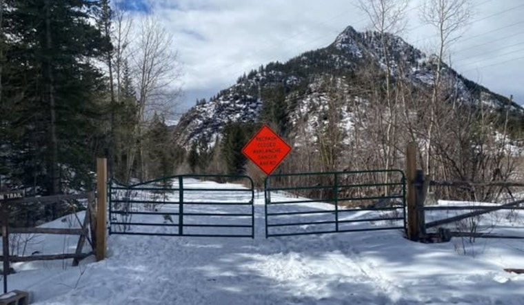
In a Facebook post on Feb. 24, Summit County Government, Colorado announced that the Tenmile Canyon recpath is closed "for the winter season." It warned that "heavy loading above from the previous storm and upcoming high winds could make it possible for an avalanche reaching the recpath." The county linked to additional information and urged trail users to steer clear of the canyon until conditions improve. Officials did not include any projected reopening date in the notice, signaling that the closure will depend squarely on the snowpack and weather.
Why This Stretch Of Trail Is A Slide Magnet
Tenmile Canyon sits directly beneath dozens of avalanche chutes, and it has a track record of slides that barrel across the pathway after big storms. As reported by Denver7, past avalanche cycles in this corridor have left debris piles up to 20 feet deep and forced cleanup operations that stretched on for multiple weeks. That kind of history is exactly why this piece of the network typically opens later than other segments and why county crews and researchers take a conservative, safety-first approach when winter weather turns volatile.
Checking Conditions And Getting Around The Closure
Trail users are being told to avoid Tenmile Canyon while the winter closure is in effect and to check avalanche conditions before heading anywhere in the high country. The Colorado Avalanche Information Center provides daily danger ratings along with safety guidance, and Summit County shares recpath updates through its Open Space & Trails page and social media channels. When Tenmile is closed, some people connect around the area using the Vail Pass recpath between Copper and Vail or ride the Summit Stage to bypass the canyon, but both access and transit schedules can shift with the weather.
Trail Basics And Access Points
The Tenmile Canyon recpath is a paved, multiuse route that links Frisco and Copper Mountain and plugs into the broader Summit County recpath network relied on by local commuters and seasonal cyclists alike. Trail guides highlight parking and trailheads near Frisco's marina and along Copper Mountain's frontage road, and they consistently note that the canyon segment is especially sensitive to storms because of the steep avalanche terrain looming overhead.
For updates on when the closure might lift and how to travel safely, check the Summit County Open Space & Trails page, follow the county's social channels, or consult the latest forecast from the Colorado Avalanche Information Center. Summit County lists contact details for its Open Space & Trails staff on its website for anyone with specific questions.


